Cartography
IBGE updates the Continuous Cartographic Base of Brazil in 1:250,000 scale


December 08, 2021 10h00 AM | Last Updated: December 09, 2021 11h55 AM
Highlights
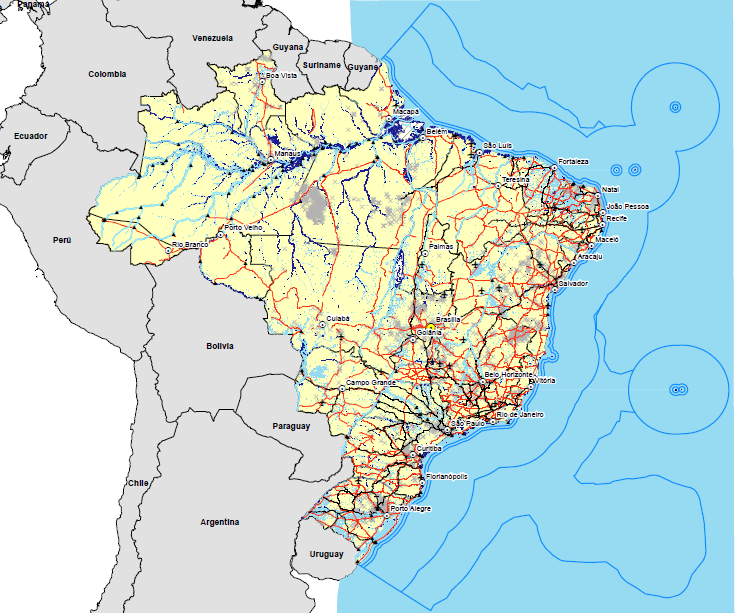
- The Cartographic Base of Brazil is in the 1:250,000 scale, in which 1cm on the map is equivalent to 2.5km on the ground.
- Updated by IBGE every two years, the cartographic document is essential for territorial planning, monitoring and management.
- Among the improvements in the new version is the addition of a new class, which brings the delimitation of the Territorial Sea, the Contiguous Zone, the Exclusive Economic Zone and the Continental Shelf.
- The product enables thematic mapping of population, geology, vegetation, soils, natural and environmental resources, among others.

The IBGE launches today (December 8) the new version of the Continuous Vector Cartographic Base of Brazil in the 1:250,000 scale, in which 1 cm on the map is equivalent to 2.5 km on the ground. This is the fifth edition of the BC250, first released in 2013 and updated every two years.
The Cartographic Base offers an overview of the territory and is a reference to territorial planning, monitoring and management, enabling the thematic mapping of population, geology, vegetation, soils, natural and environmental resources of the country, among other themes.
“By means of the Permanent Update Program of the BC250, it is possible to provide society with a digital, geospatial database, which is planimetric, standardized, continuous and up-to-date of the whole Brazilian territory in the 1:250,000 scale, which allows access to information relative to positioning, geographical names and classification of the represented elements”, explains Mr. Rafael Balbi, geoprocessing analyst and manager oft IBGE’s Continuous Bases.
The 2021 version of the BC250 from satellite images covering the whole national territory, with data produced by other IBGE surveys and data from partner-bodies, which enabled the updating of several information of the 2019 version.
Among the improvements of the fifth version are the topological quality control editions, inclusion of mandatory requirements in data modeling, addition of a new class (delimiting the Territorial Sea, the Contiguous Zone, the Exclusive Economic Zone and the Continental Shelf, in addition to th complementation of same other classes, as for instance, sluice gates and waterway sections.
The products comprises classes of 13 information categories: Energy and Communications; Economic Structure; Hydrography; Borders and Localities; Relief; Transportation System; Transportation System/Airport; Transportation System/Pipes; Transportation System/Railway; Transportation System/Waterway; Transportation System/Roadway; Base of Topographic Mapping in Large Scales; and Culture and Leisure.
The new version also presents the list of geographic names, in the CSV format, to be viewed in a GIS (Geographic Information System) environment, where its is possible to locate, through geographic coordinates, all the geographic names that comprise the base, represented by dots.
Built according to the norms in force, the base is compatible with the accuracy requirements of the National Cartographic System (SCN) and adequate to the standards and norms of the Brazilian National Spatial Data Infrastructure (INDE). The data are structured according to the conceptual model of the Technical Specifications for the Structuring of Vector Geospatial Data, Version 3.0 (ET-EDG V 3.0).
“The BC250 is the spatial representation of Brazil in the Integrated Map of South America, organized by the Pan American Institute of Geography and History - PAIGH.” adds Mr Balbi. He explains that the product is meant to any user of Geographic Information System and of the Geographic Database (BDG).
BC250 is available for free (shapefile, geopackage and dump of PostGis), to be used in Geographic Information Systems, and it can be accessed here or on the IBGE's Interactive Geographic Platform.
More detailed information about the cartographic base can be seen in the technical note enclosed in the product, available here. The 2021 version of the BC250 can also be accessed through the geoportal of INDE and its metadata can be found in the IBGE´s Metadata Directory.