Environmental-Economic Accounting
Between 2000 and 2020, agricultural area grew 230 thousand km², natural vegetation reduced 513 thousand km² in Brazil


October 07, 2022 10h00 AM | Last Updated: October 10, 2022 01h27 PM
Highlights
- Between 2000 and 2020, rural vegetation reduced by 10.6% in Brazil (192.5 thousand km²), whereas forest vegetation reduced by 7.9% (320.7 thousand). Together, these two types of cover lost 513.1 thousand km² between 2000 and 2020, the equivalent to 6.0% of the Brazilian territory.
- In the same period (2000-2020), the area of silviculture grew 71.4% in Brazil (36 thousand km²), agricultural area grew 50.1% (229.9 thousand km²) and that of pasture with management, 27.9% (247 thousand km²).
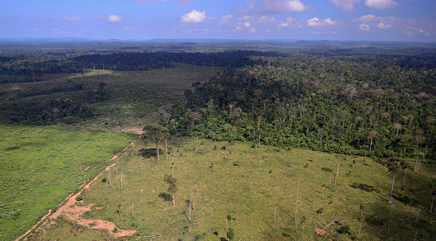
- The most intense changes were in the outskirts of the Amazon, in MATOPIBA, in the southe of Rio Grande do Sul and in the area from the west of São Paulo to the east of Mato Grosso do Sul and Goiás.
- Agricultural areas stood out, especially in the states of Mato Grosso (18.1%), São Paulo (14.9%), Rio Grande do Sul (14.3%) and Paraná (10.5%), with the biggest percentages of land in this class in relation to the entire country.
- The stock of agricultural areas expanded in Maranhão (2.8 p.p.), Tocantins (4.4 p.p.), Piauí (3.8 p.p.) and Bahia (2.7 p.p) in the period between 2000 and 2020.
- Pará was the Federation Unit with the largest expansion of pasture with management: 87.8 thousand km²; and with the largest reduction of natural vegetation, 123.2 thousand km²
- Between 2018 and 2020, 70 thousand km² of the Brazilina territory suffered some kind of change in land use and cover, corresponding to 0.7% of the national territory or an area equivalent to that of Alagoas and Rio de Janeiro.
- In this period (2018-2020), the major conversions were from pasture with management to agricultural area (14.9 thousand km²), from mosaic of occupations in forest area to pasture with management (12.3 thousand km²) and from forest vegetation to mosaic of occupations in forest area (11.8 thousand km²).
The IBGE released today (7) the Environmental-Economic Accounting for Land: Physical Accountability, an unprecedented survey that unveils the changes in the stock of that resource in Brazil between 2000 and 2020. The publication is based on the results of Monitoring Land Use and Cover, carried out and released in this period.
The reduction in the areas of natural vegetation in Brazil is among the major results. Rural vegetation retracted 10.6% (192.5 thousand km2), whereas forest vegetation reduced its territory by 7.9% (320.7 thousand km2). Together, they reduced by 513.1 thousand km2 between 2000 and 2020.
Among the expansions, silviculture stood out, the change process with the highest percentage growth in 20 years, with an expansion of 71.4% (36 thousand km2). It was closely followed by the agricultural area, which represented a growth of 50.1% (229.9 thousand km2). Still among the expansions, pasture with management grew 27.9% in the period, an increase of 247 thousand km2.
Despite the changes in this period, forest vegetation remains the largest class in extension of land cover in Brazil, though its share reduced from 46.2% to 42.5% of the total area. The area of rural vegetation reduced from 20.8% to 18.6%. The next two classes grew: Pasture with management, from 10.1% to 12.9% and agricultural area, from 5.2% in 2000 to 7.9% in 2020.

Concerning the share in conversions between land stocks, forest vegetation (40.4% of the total) and rural vegetation (24.3%) stood out, which means that natural vegetation represented 64.7% of the total number of conversions in 20 years. In this period, nearly 98.4 thousand km2 (18.2%) of natural vegetation was converted into agricultural area. It was closely followed by mosaic of occupations in forest area, with 19.2% of the total. Considering that class, 41.6 thousand km2 (20.5%) of land was converted into agricultural area.
Still concerning land conversions in the period (2000-2020), 72.5 thousand km2 of rural vegetation and 85.3 thousand km2 of pasture with management were converted into agricultural area. That amount, 157.7 thousand km2 of land, corresponds to 65.6% of the total land converted into agricultural area.
In addition to the agricultural dynamics, 149.3 thousand km2 of forest vegetation was converted into pasture with management in the period, which represents 43.8% of the total number of conversions over forest vegetation. “The survey unveils a trend for use conversion, highlighting the expansion of agricultural areas over rural vegetation and pasture with management, as well as a growth in pasture with management over forest vegetation,” develops Ivone Lopes Batista, manager of the survey.
The analyses of the publication show the change dynamics, highlighted by the outskirts of Amazon, MATOPIBA, south of Rio Grande do Sul and the stretch that includes the west of São Paulo and east of Mato Grosso do Sul and Goiás. “These conversions are unequal in the territory. In some areas they advance a lot and, in others, they are limited by special areas like Conservation Units and Indigenous lands,” explains Batista.
Pará had the largest expansion of pasture with management and the largest reduction of native vegetation
Among the Federation Units, the largest expansion in areas of pasture with management was in Pará: more 87.8 thousand km2 in 20 years. It was followed by Mato Grosso (45.9 thousand km2) and Rondônia (35.9 thousand km2). In the same order, the three states registered the biggest reductions of natural vegetation: 123.3 thousand, 97.8 thousand and 40.8 thousand km2, respectively.
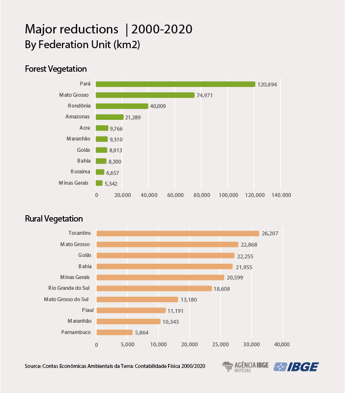
In Pará, natural vegetation retracted by 123.2 thousand km2, whereas in Mato Grosso the reduction was of 97.8 thousand and in Rondônia, 40.9 thousand. “An expansion of pastures with management from the Central-West Region to the North Region can be noticed,” explains Batista. In the agricultural areas, the largest expansions were in Mato Grosso (56 thousand km2), São Paulo (23.8 thousand) and Goiás (21.3 thousand).
Silviculture advanced mainly over areas of rural vegetation, mosaic of occupations in forest area and pasture with management. The largest expansions were in Mato Grosso do Sul (7.8 thousand km²), Minas Gerais (6.6 thousand km²) and Rio Grande do Sul (4.8 thousand km²).
Between 2018 and 2020, land use has changed an area equivalent to Alagoas and Rio de Janeiro
The updating of “Monitoring Land Use and Cover in Brazil” was also released today, including the territorial changes in Brazil between 2018 and 2020. In this period, 70 thousand km2 of the national area suffered some kind of change, corresponding to 0.7% of the national territory or an area equivalent to the states of Alagoas and Rio de Janeiro together. The major change was the advance of agricultural activities over natural vegetation.
In this period (2018-2020), the major conversions were from pasture with management to agricultural area (14.9 thousand km2), from mosaic of occupations in forest area to pasture with management (12.3 thousand km2) and from forest vegetation to mosaic of occupations in forest area (11.8 thousand km2), which represents a fragmentation of the landscape.
Some Brazilian regions stood out: center-north of Mato Grosso; east-northeast of Pará; borders of Rondônia, Acre and Amazonas; Savannah region of Roraima; MATOPIBA; west of São Paulo and east of Mato Grosso do Sul, Goiás and Triângulo Mineiro; as well as the south of Rio Grande do Sul.
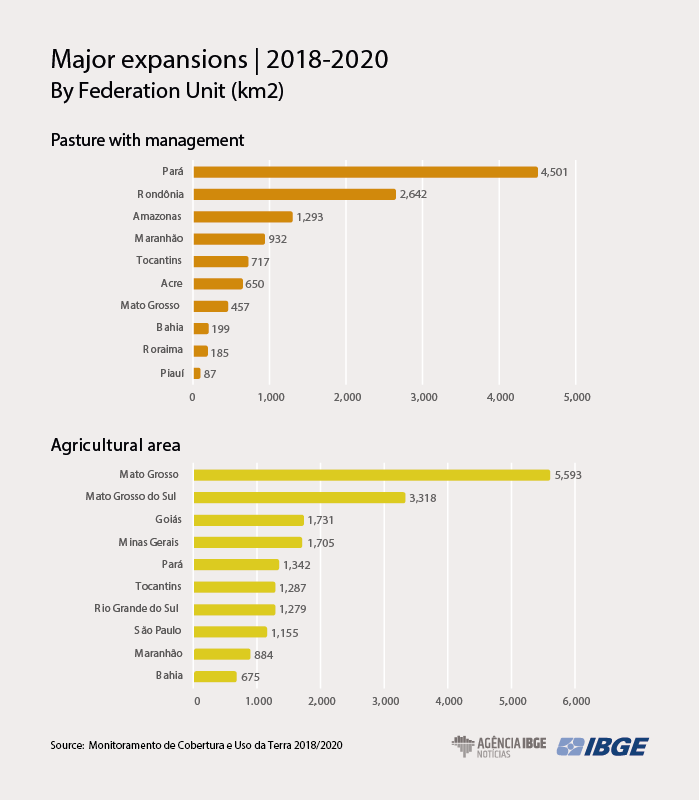
In two years, the largest expansions of pasture with management were registered in Pará (4.5 thousand km²), Rondônia (2.6 thousand km²) and Amazonas (1.2 thousand km²). Agricultural areas gained more space in Mato Grosso (5.5 thousand km²), Mato Grosso do Sul (3.3 thousand km²) and Goiás (1.7 thousand km²). Silviculture expanded more in the states of Mato Grosso do Sul (329 km²), Maranhão (230 km²) and Bahia (138 km²).
The survey also captures the reductions in forest and rural vegetation between 2018 and 2020. In the former, the highlights were Pará (4.7 thousand km²), Mato Grosso (2.4 thousand km²) and Rondônia (2.1 thousand km²). In the latter, Tocantins (1.8 thousand km²), Mato Grosso (1.4 thousand km²) and Rio Grande do Sul (1.1 thousand km²) led.
Visual interpretation of satellite images and field campaigns
Monitoring Land Use and Cover aims at spatializing and quantifying land use and cover in Brazil at regular periods, based on systematic mappings. The methodology involves visual interpretation of satellite images, field campaigns and consultation to complementary information. The data are released in Statistical Grid, which covers the Brazilian territory in 1 km2 cells. As by-products, maps, graphs and tables are made available with statistics that comprise the Physical Accounts and the Matrix of Changes occurred in the periods under analysis.
IBGE updates databases of the “Ecosystems Accounts: Land Use in Brazilian Biomes”
The IBGE also releases today the updating of the databases of the Ecosystems Accounts: Land Use in Brazilian Biomes, another step of the project of including Brazilian environmental indicators in the National Accounts. The study, based on summary data of Monitoring Land Use and Cover, shows an analysis of the extension of natural and anthropized areas in the biomes, taking into account conversions of land use in the 2018-2020 period. The entire adjusted time series is also available.
Interactive consultation of data and by-products can be made through the Environmental Information Database and the Interactive Geographic Platform.