Mapping
IBGE launches publication with sampling strategy for mapping land use and cover


June 15, 2026 10h00 AM | Last Updated: June 16, 2026 10h58 AM
The IBGE, by means of the Environmental Coordination of the Directorate of Geosciences, released today (15) the discussion paper Sampling Strategy for Land Use and Cover Mapping, a document that brings together methodological and operational fundamentals aimed at improving the production of geospatial information in official statistics.
The publication presents an exploratory model, initially applied in a pilot study area for testing, and proposes guidelines for defining sampling strategies that increase efficiency, precision, and representativeness for the production of land use and land cover mapping throughout the national territory. This is a version intended for technical debate with stakeholders, so that the strategy can be developed into a versatile and replicable protocol.
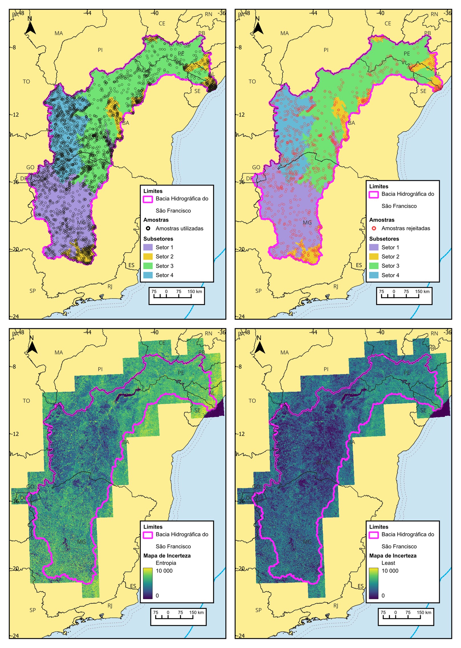
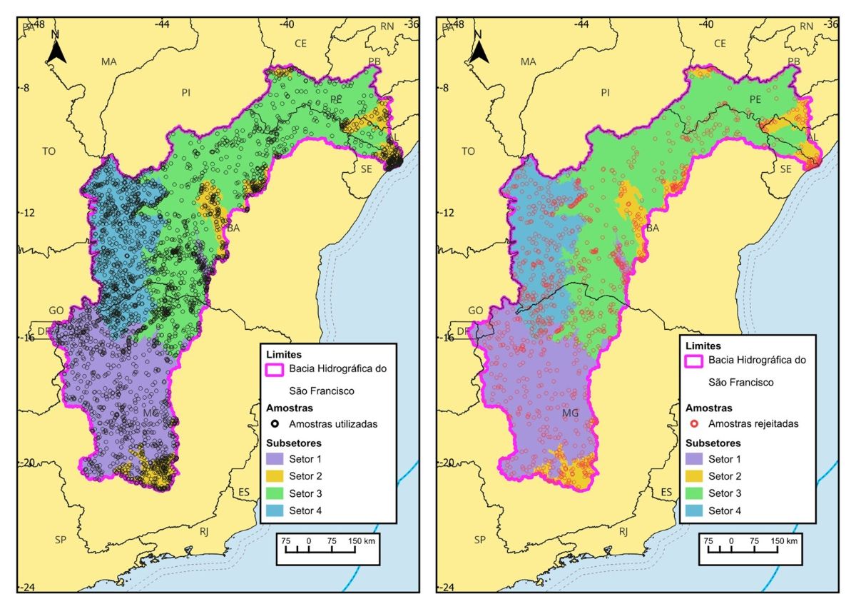
The São Francisco River Basin was selected as a pilot area because it has characteristics that favor the assessment and adjustment of the proposed methodology. Its territorial extension and diversity of land use and cover offer a representative scenario of different environmental realities and landscape complexes. Thus, it makes it a suitable laboratory to assess the applicability of the model in contexts of national interest, before its expansion to other areas of the country.
The text innovatively addresses the integration of statistical techniques and geotechnologies, combining pre-existing land use mapping with predictive analyses that estimate probabilities and uncertainty metrics by class, through the application of machine learning algorithms. The proposal allows for the identification of gaps in sample representativeness and the prioritization of areas for additional data collection, providing support for balancing the number of sampled points and the quality of the classification.
The remainder is temporarily in Portuguese.
Thus, the product aims to describe processes focused on guaranteeing the quality of data that will serve as input for Artificial Intelligence models, designed to ensure reproducibility and transparency, without preventing necessary methodological adjustments during the pilot phase and subsequent scaling up to the entire national territory. The modular structure of the designed method facilitates the scalable application of routines and the incorporation of improvements based on empirical evidence.
“The objective is to provide a technical basis that guides the optimization of sampling and the subsequent validation of the model, seeking to guarantee the representativeness of the multiple elements that make up the diversity of Brazilian landscapes, to generate better results predicted by AI,” commented the Manager of Land Use and Cover Observation, Cássio Almeida. He also highlights that the initiative contributes to the integration of geospatial data and automated analyses in environmental monitoring processes and in the production of official statistics.
The results reflect IBGE's institutional commitment to the continuous improvement of its statistical and geoinformation production processes, as well as to the expansion of public and transparent access to its methodologies. The initiative aligns with international data quality and governance frameworks, such as the Fundamental Principles of Official Statistics and the guidelines of the Geospatial Information Management Group, both from the United Nations.
These references guide the production of impartial, transparent, and comparable statistics, as well as the responsible management and integration of geospatial information, reinforcing the need for verifiable methodologies. This ensures that the information produced by the Institute meets international standards and serves as a reliable basis for public policies and monitoring of global commitments.
Specifically regarding land use and cover, the Environment Coordinator, Maria Luisa Pimenta, highlighted the need for methodological updates to meet current demands: “It is necessary to review mapping methodologies and scales to produce more granular information more quickly, capable of supporting timely public decisions. This implies calibrating protocols, adopting modular approaches, and integrating automated techniques that allow for the validation of results, thus guaranteeing data quality and confidence in the information generated.”