Censo Agropecuário
IBGE releases thematic maps of Census of Agriculture in digital platform


December 19, 2018 10h00 AM | Last Updated: December 19, 2018 11h48 AM

The IBGE released today, December 19, the thematic booklet Geographies of the Brazilian Agriculture - A Territorial View of the Preliminary Results of the 2017 Census of Agriculture, of the Digital National Atlas 2018. Including maps, graphs and explanatory texts on the themes surveyed in the 2006 and 2017 Censuses of Agriculture, the product approaches the spatial dynamics of the Brazilian agriculture, aiming at understanding the space reorganization in Brazil.
It comprises 52 boards, 151 maps and 135 graphs with the main preliminary results of the Census of Agriculture released in July. "We worked on themes like size of the establishments, Internet in the countryside, use of agrotoxins, schooling and age of rural producers and distribution of the major agricultural products, mapping them on a municipal scale", explains Marcelo Delízio, of the IBGE´s Coordination of Geography.
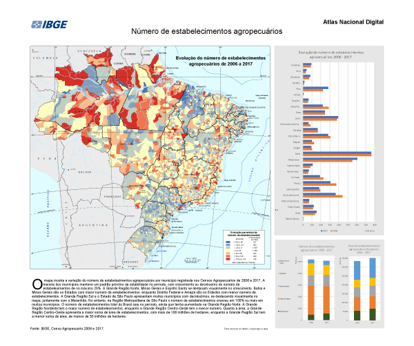
based on the preliminary data of the 2017 Census of Agriculture
The booklet is part of the Digital National Atlas and it is also available in an interactive geographic platform, which makes the contents available in PDF and geo-services.
Delízio highlights that other territorial divisions are analyzed, like the Semiarid region, which housed more than 70% of the increase in the area occupied with agro-forestry. The interactive environment allows to associate other information to the maps, like layers with the distribution of railways, waterways and highways: "for example, we can check whether there is a railway along an agrarian axis", explains the researcher.
"We hope that students, researchers, public managers and the third sector use these analyses a lot. We managed to show how the Brazilian territory gets different according to the variables that the census made available", concluded Delízio.