2022 Census
IBGE uses interactive geographic platform to monitor 2022 Census data collection


January 10, 2023 09h00 AM | Last Updated: January 16, 2023 09h52 PM
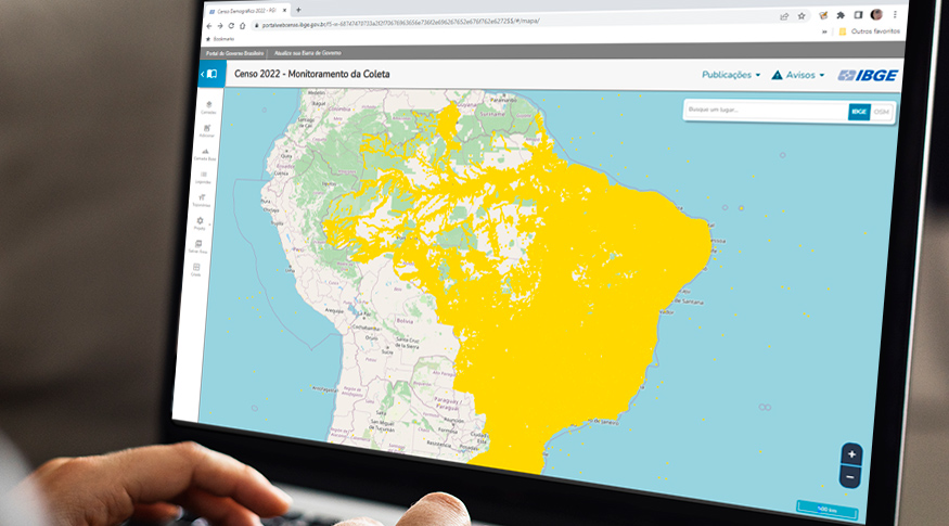
The Interactive Geographic Platform (IGP), used in the release of IBGE geosciences products, is also being used for the monitoring of 2022 Census enumerators. As a result, the Institute can check the status of data collection by enumeration area on an interactive map. Last Friday (6), in a seminar, IBGE technicians were shown the functionalities of this platform for operation control.
The event was an opportunity to present the IGP as a support tool in the census operation. Attendants learned how to access the platform, what its main layers are and how this type of information can be used in Census coverage for each geographic level available. In the protocol for finishing data collection, the platform is adopted together with other tools, such as the Integrated Management and Control System (SIGC, in Portuguese) and the Census dashboard.
“The IGP has been used in the releases of geosciences for almost a decade and for the dissemination of information in a more interactive way. It is the first time we use this platform in a Census, as a tool for visualization, data collection monitoring and possible initial analyses,” says Miriam Barbuda, IBGE deputy Geosciences director.
The researcher adds that, in order to monitor data collection, it was necessary to develop some geoprocessing functionalities. “The IGP indicates, by means of geospatial monitoring, if all the housing units have coordinates. This capture of coordinates started in the 2017 Census of Agriculture, in all the rural addresses, and, in the 2022 Census, this innovation will reach all housing units in the country”.


Indicator categories have been developed to be used in the 2022 Census: one for monitoring and one for alert. “The idea is to provide material in order to improve Census geographic coverage and quality by means of spatialization of tools, of these indicators. Geospatial alert indicators are basically used in the activity of data collection supervision and monitoring management,” explains the IBGE geoprocessing analyst, Rafael Damiati.
Besides geosciences products, like the Area of Influence of Cities (REGIC), the IGP has been made available to external users in other INGE releases, such as the GDP of Municipalities and Continuous PNAD. As for the monitoring of activities in Census coverage, the tool is for internal use.
“In the 2022 Census, it has been adapted, improved with new functionalities to allow geospatial visualization of monitoring and alert indicators. The result of this work provides the user with more interactivity and highly granular data.”
“It allows one to see how data collection is, the percentage of housing units visited, and of enumeration areas, with a spatial view. There is also the possibility of checking coverage in comparison with addresses in the Brazilian Electricity Regulatory Agency (ANEEL), ” Ms. Barbuda says.
She explains how the platform can be used in data collection supervision. “When, for example, there is a locality with a very high percentage of refusals or of absent residents, it is possible to analyze the situation, since, spatially, you can see and associate to it an area of work. If there is a pattern, it has to be assessed by local teams.”
A possibility for the IGP is to check if the enumerator faced difficulties when he recorded the coordinate for a given housing unit. When conducting this monitoring by sector, the servant can also see the number of confirmed addresses without coordinates; this percentage has been low, in general. In this case, he has to compare field information with data available in the SIGC in order to assess each case.
There are a total of 12 indicators available in the Census IGP, among which are one for confirmation of addresses of the National Address List for Statistical Purposes (CNEFE), one for validation of coordinates and another one for addresses excluded in a visit.
In the seminar, Ms Barbuda also mentioned the use of this platform as an important tool for analyses that precede the Meetings for Planning and Monitoring of the Census (REPACs). These meetings are intended to guarantee more transparency to the operation, with participation of the local community and of municipal representatives.
“In these meetings, we show the city administration how coverage is inside the municipality. It is important to promote this monitoring in advance with the use of the IGP, in order to identify possible problems. Many tools help us guarantee full coverage, something not seen in previous Census editions.”