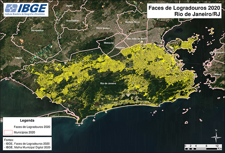
Mapping
Block-face Database for Public Areas increases 29% between 2010 and 2020


July 13, 2021 10h00 AM | Last Updated: July 13, 2021 01h45 PM
Highlights
- Digital database brings graphical representations of blocks, streets and squares in the cities and in the countryside.
- Used in the IBGE´s household surveys, it can also be useful to city halls and logistics enterprises, as well as to build map routes on the Internet.
- 2020 version increases 29.1% in relation to that of 2010.
- All the geospatial information are in SHP format (shapefiles) to be applied in different geographic information systems.
The IBGE publishes today (13) the Block-face Database for Public Areas 2020, which encompasses urban areas, areas of urban extension and areas of rural agglomerates of all the Brazilian municipalities. The new version shows an increase of 29.1% in the lines that comprise the database in relation to 2010.
Used by the IBGE to guide its household surveys, vector files are released annually for download and can be used by city halls and logistics enterprises, as well as to build map routes on the Internet.
“The 2020 version reaches 13,688,342 line segments, corresponding to the block faces of the occupied zones of the Brazilian municipalities, showing the effort of the IBGE to follow up the growth of the urbanization,” explains Diogo Nunes, manager of Infrastructure of Data and Services.
This is the second publication of the Block-face Database for Public Areas, independently of a Population or Agricultural Census, not including the records of household units enumerated. The first one was released last year.
“As there is not any formal nationwide formal database, this is the only data structure that encompasses information of block faces regardless of the information from the municipalities,” adds Nunes.
Used by the IBGE to guide its household surveys, vector files in SHP format (shapefiles) are released annually for download and can be used by city halls and logistics enterprises, as well as to build map routes on the Internet and in businesses that demand geospatial components.
Compatible with the scales from 1:5,000 to 1:25,000, the product brings the association with enumeration areas of the Mesh of Enumeration Areas, as well as in relation to the political-administrative division of the Municipal Mesh of Brazil product.
Although the IBGE processes have evolved over the years, creating better visual conditions and georreferencing the stretches of the road network, some data produced may show imperfections occasionally. Whenever using the data, users should be aware of those notes.