Territorial divisions
IBGE updates geographic divisions of reference to disseminate results of 2022 Census
July 19, 2023 10h00 AM | Last Updated: July 19, 2023 04h32 PM
Highlights
- The IBGE releases updating of geographic divisions related to 2022.
- Legal geographic divisions are administrative areas established by legislation or normative rules from other public institutions that the IBGE is committed to produce statistics relevant to public policies.
- The IBGE´s institutional divisions were specifically created for the production, dissemination and analysis of official statistics. This means that these divisions are designed to meet the requirements of the data collection and operation of the censuses and other surveys, as well as the geographic studies essential to these statistics, in order to produce varied and relevant divisions for public management and planning, as well as inputs to investments from the private sector.
- The geographic divisions, present in the Geographic Reference Framework for the Production, Analysis and Dissemination of Statistics, serve as reference to the dissemination of the results of the 2022 Census, including new borders and nomenclatures present in the 2022 Territorial Division of Brazil.
- In 2022, the municipal composition of some Metropolitan Areas was changed, as well as of the Semiarid and Municipalities of the Borderland Strip and Twin Cities. A new division was included as well, that of the Municipalities of the SUFRAMA´s Operational Area.
- In the Metropolitan Divisions, a new Metropolitan Area was created in Piauí and Metropolitan Areas were adjusted in Alagoas.
- The Brazilian Semiarid now comprises more 215 municipalities, adding up to 1,477 municipalities of the states of Maranhão, Piauí, Ceará, Rio Grande do Norte, Paraíba, Pernambuco, Alagoas, Sergipe, Bahia, Minas Gerais and Espírito Santo.
- Thirty-three Twin Cities were incorporated to the list of 588 municipalities distributed along 11 states of the Brazilian Borderland Strip with South American countries.
- This is the first time that Municipalities in the SUFRAMA´s Operational Area are included in the IBGE´s base of legal geographic division.
- The IBGE also adjusted the border of several divisions to be compatible with the 2022 municipal mesh. They are: Legal Amazon, Municipalities from SUFRAMA´s Operational Area, SUDENE´s Operational Area, Semiarid, Municipalities Facing the Sea, Coastal Municipalities, Municipalities of the Borderland Strip, MATOPIBA, Population Arrangement, Urban Concentration, Urban Hierarchy, Geographic Meso-region, Geographic Micro-region, Metropolitan Division, Metropolitan Category, Metropolitan Sub-Category, Urban Agglomeration, Immediate Geographic Region, Intermediate Geographic Region, Enhanced Region of Urban Articulation, Intermediate Region of Urban Articulation, Immediate Region of Urban Articulation and Rural Region.
- All the divisions are available in the Geographic Framework and can be accessed on the Interactive Geographic Platform (PGI) as maps.
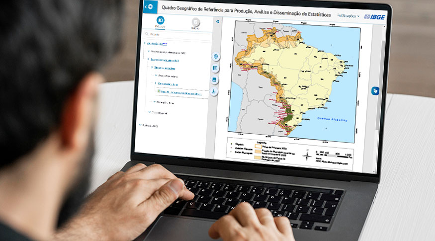
The IBGE released today (19) the 2022 edition of the Geographic Reference Framework for the Production, Analysis and Dissemination of Statistics, which gathers technical sheets and thematic maps of legal and institutional territorial divisions of Brazil. The Framework is available on the Interactive Geographic Platform (PGI), including information about the divisions and their interactive maps.
“The Geographic Framework is one of the international good practices to integrate statistical and geospatial information. We are updating the geographic divisions with the 2022 municipal mesh, so as to reflect the changes introduced in the borders and in the names of municipalities. It aims at allowing users to have the best information possible, by crossing the 2022 Census data with territories structured in the same reference date,” explains Cayo Franco, the IBGE Coordinator of Geography.
Each geographic division in the Framework shows information like the updating cycle and the last legislation/definition updating, the amount of units and municipalities, the publication/legislation of reference and the date of the next release. The Geographic Framework also allows to recover previous versions of some divisions, which helps to understand their changing process.
The main news are related to legal territorial divisions. In 2022, municipal compositions were changed in the Metropolitan Areas (RMs), Semiarid and Municipalities in the Borderland Strip and Twin Cities.
“Municipalities of the Operational Area of the Superintendence of the Free Zone of Manaus (SUFRAMA) were incorporated and the Semiarid, updated. For the first time ever, Twin Cities are being presented in the Borderland Strip, as well as regular updatings in relation to Metropolitan Areas and Urban Agglomerations,” highlights Franco.
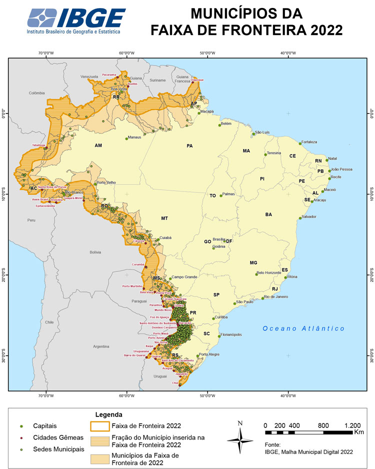
Geographic Framework shows new metropolitan area in Piauí, inclusion of 215 municipalities in the Semiarid and 33 twin cities
The Metropolitan Area of Parnaíba in Piauí was created in the Metropolitan Divisions. Metropolitan Areas in Alagoas were adjusted as well.
The Brazilian Semiarid now comprises 1,477 municipalities, belonging to the states of Maranhão, Piauí, Ceará, Rio Grande do Norte, Paraíba, Pernambuco, Alagoas, Sergipe, Bahia, Minas Gerais and Espírito Santo. Of this total, 1,212 municipalities were already included in the previous delimitation and were confirmed. Other 215 municipalities qualified, according to the new criteria adopted. It should be mentioned that 50 municipalities included in the previous delimitation would not integrate the Semiarid, as they did not hit any of the technical criteria established. However, these 50 municipalities were allowed to appeal for their exclusion from the Semiarid up to April 2023. As the current release corresponds to the status of the territorial division up to December 31, 2022, the IBGE decided to keep not only the municipalities included in the Semiarid according to the changes, but also those that might be excluded, as explained in the resolutions no. 155, of April 29, 2022, and no. 163, of December 15, 2022, of the SUDENE´s Advisory Board.
Concerning the 588 municipalities in the Borderland Strip, distributed along 11 states, 33 Twin Cities were incorporated like, for example, Pacaraima (RR), Ponta Porã (MS) and Foz do Iguaçu (PR). The Brazilian Borderland Strip with South American countries is 150 km long and shows a total area of 1,421,344.688 km2, corresponding to nearly 16.7% of the Brazilian territory. Twin Cities can be defined as those cities located beside each other, though in different countries.
“The correlation of the updatings of the geographic divisions with 2022 Census data is extremely important, as it allows the society and several institutions to analyze specific issues in the entire country. It provides a huge assessment power to help decisions involving issues of public policies and private interests,” states Roberto Tavares, the IBGE Coordinator of Territorial Structures. He highlights the relevance of the new information available on the Borderland Strip and Twin Cities. “They are important updatings in any aspect: social, economic, cultural and of public security. These areas require a different perspective from the federal government, taking into account the extension of 16.9 km of the border.”
The Geographic Framework comprises two major groups. The legal territorial divisions published by the IBGE include: the political-administrative division (Major Region, State, Federal District, Municipality, District, Sub-District and Neighborhood), the regional division (Metropolitan Division, Metropolitan Category, Metropolitan Sub-Category, Urban Agglomeration, Legal Amazon, SUDENE´s Operational Area, Municipalities of the SUFRAMA´s Operational Area, Semiarid, MATOPIBA, Coastal Municipalities, Municipalities Facing the Sea and Municipalities in the Borderland Strip and Twin Cities) and the geographic typologies (Urban Area, Rural Area and Indigenous Land).
On the other hand, the IBGE´s institutional territorial divisions are divided into: units of data collection and dissemination of surveys (Enumeration Area, Weighting Area, Sample Dissemination Area for Subnormal Agglomerate, Grids of Statistical Reference, Block and Address), geographic typologies (Urban Area of High Density of Constructions, Urban Area of Low Density of Constructions, Rural Area (excluding Agglomerates), Urban Core, Subnormal Agglomerate, Rural Agglomerate, Indigenous Village, Agro-Villa of Settlement Project, Other Types of Enumeration Areas, Population Arrangement, Urban Concentration and Urban Hierarchy), regional divisions (Geographic Region, Geographic Meso-region and Micro-region, Urban-Regional Division and Rural Region) and specific division (Biome).
IBGE and legal and official territorial divisions
The updating of Brazilian legal or official territorial divisions meets the commitments taken by the IBGE with the Brazilian society. On an annual basis, the IBGE publishes the most relevant territorial divisions for the production of surveys and statistics that will produce knowledge about Brazil, thus fulfilling its institutional mission of portraying Brazil with information necessary to know its reality and to the exercise of citizenship. Even not being the office responsible for creating and updating many of these divisions, they are present, on a daily basis, in the life of millions of Brazilians. For this reason, they are relevant for the production of information able to change Brazil for the better.


