Cartography
IBGE releases new edition of Political Map of Brazil


November 28, 2022 10h00 AM | Last Updated: November 30, 2022 04h44 PM
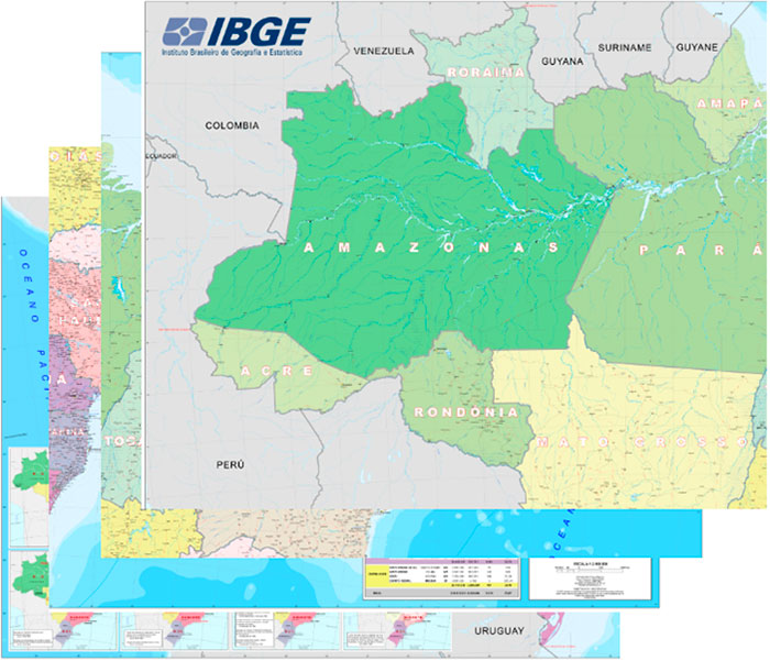
The IBGE releases today (28) the 2021 version of the Political Map of Brazil in the 1:2,500,000 scale, where 1 cm is equivalent to 25 km in the terrain. A cartographic representation of the entire Brazilian territory, the map represents the political-administrative organization of the country, comprising its 26 states and the Federal District. It also includes the capitals of every Brazilian municipality, as well as other cartographic information.
The map is produced by the IBGE since 1940, and this edition portrays the evolution of the Brazilian territorial division up to 2010, when the last Population Census was accomplished. The new version of the Political Map is available in GeoPDF format and can be accessed here. The metadata can be found in the IBGE catalog.
Based on the Continuous Cartographic Base of Brazil in the 1:250,000 scale (BC250), the new product provides a view of the entire territory. The map allows to pinpoint the 27 Federation Units and their capitals, and the capitals of all the 5,570 municipalities, as well as other geographic elements that complement and characterize them. Students and education professionals, at every level, as well as public and private institutions are potential users of this product.
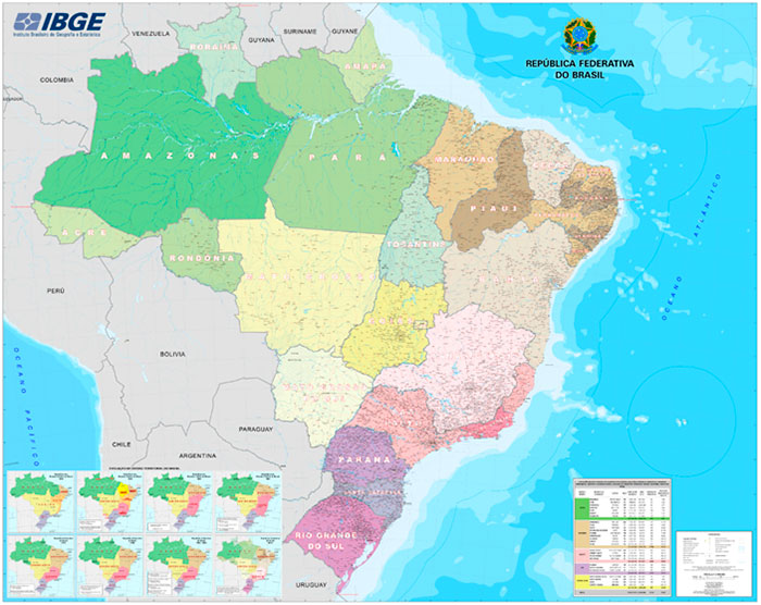
It is also possible to pinpoint the following categories on the map:
Hydrography: water bodies, islands and terrains subject to flood;
Transportation system: roads, railroads, ports and airfields;
Localities: classified according to the 2021 population estimate;
Borders: international (informative character), state, Federal district and maritime;
Energy and communications: plants;
Reference points: extreme points;
Relief: mountains and peaks;
Toponymy: according to criteria established by the IBGE.
The new edition of the Political Map of Brazil introduces new features in relation to the previous publication. According to the head of the IBGE´s sector of Map Design, Ludolf da Mota, the major changes are related to the inclusion of features not mapped in the previous version, involving elements that integrate airport, road and railway systems, associated with the generation of energy, like new hydroelectric plants.
“There is also an additional work of standardizing the names of geographic features like, for example, water courses, localities, hills and roads existing in the territory. Another relevant change in the product is the updating of the population estimates of cities, states, Federal District, Major Regions and Brazil. These changes can be noticed in the symbology of the cities represented in the conventions chart of the Map and in the table of population estimates for 2021,” complements Mota.
The Political Map of Brazil 1:2,500,000 is available in digital version by means of a single file split into four quadrants, due to its large size (1.80 m x 2.26 m). “This is the largest wall map ever produced by the IBGE, exhibited in rooms of several federal institutions. Although the map is produced in a single size, its distinctive size caused it to be split into four quadrants, equally published, to streamline printing and handling,” explains the head of the IBGE´s sector of Map Editing, Paulo Renato.