BC100 Project
IBGE launches Cartographic Basis for Alagoas State


November 18, 2022 10h00 AM | Last Updated: November 19, 2022 02h44 AM
Highlights
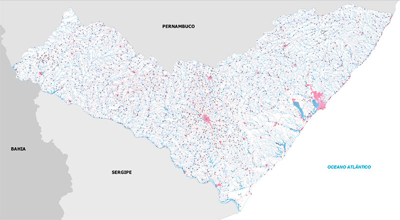
- Continuous Cartographic Basis for the state of Alagoas (BC100_AL) is part of the Projet BC100, which intends to map the 27 Federation Units at the 1:100,000 scale.
- The cartographic product is essential for the planning of infrastructure construction works, such as those in the transportation and communication sectors.
- BC100_AL has a layer of additional information called “Name Index”, corresponding to the nomenclature of elements that are part of it.
- That is the second cartographic basis for a northeastern state. The first one covered Sergipe, in 2019.
- Besides Sergipe, within the Project BC100 bases for Rio Grande do Sul, Espírito Santo, Goiás and the Federal District have been released
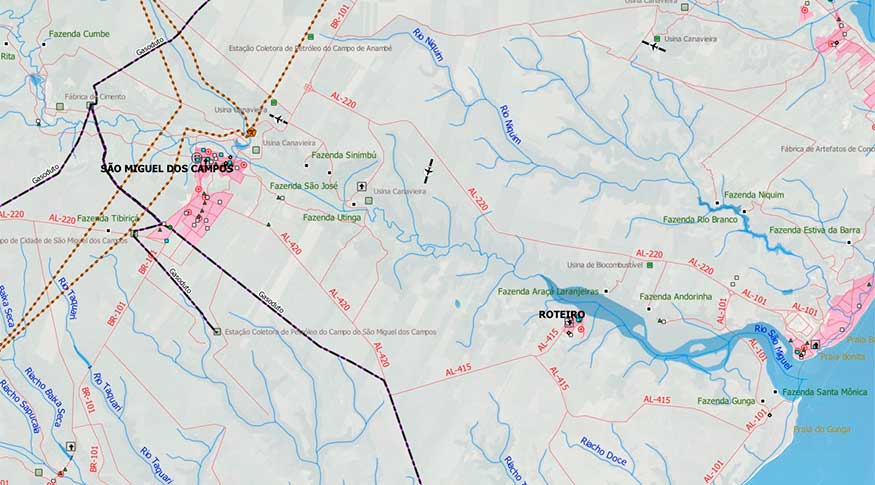
The IBGE launches today the Vector Cartographic Basis for the state of Alagoas at the 1:100,000 scale, in which 1cm corresponds to 1km of land. The release is part of the BC100 Project, which has the objective of mapping all the 27 Federation Units at this scale. Alagoas is the sixth FU included in the group of published geospatial data, together with Rio Grande do Sul, Sergipe, Espírito Santo, Goiás and the Federal District.
The new product is available as open files (Shape File, GeoPackage and dump from the PostGis database), for use in Geographic Information Systems and by means of geoservices, via Geographic Interactive Platform..
“The main applications for this database are in the sector of planning of infrastructure construction works, in the development of governmental products focused on the territory, in analyses that require a combined view of the geographic space and as a subsidy in the spatial representation of social, economic and environmental aspects of the territory,”, says the manager of IBGE Continuous Cartographic Bases, Rafael Balbi Reis.
Being the second state cartographic base in the Northeast Region, BC100_AL illustrates the continuous improvement of the process of acquiring categories and classes of geographical information in comparison with that of Sergipe, released in 2019. In rural areas, for example, BC100_AL presents information on buildings that represent the main rural properties and most significant industrial areas in the state. “There have also been efforts to represent facilities in the teaching, health and religious sectors, which are used as spatial references,” says Geraldo Santos Landovsky, IBGE Cartography supervisor in Ceará.
“Improvements also encompass aspects of attribute filling, geographic names, analysis of the interrelation between classes of geographic objects in the regional context, as well as the expansion of the number of classes mapped,” Mr. Landovsky explains.
The product also presents a layer of additional information called “Name Index”, corresponding to the names of elements forming it. The layer allows spatial location of names represented by points, associated to their respective categories and classes of mapped elements.
“In the two previous versions, this piece of information was presented by mean of a text attached to the data, requesting from the user the execution of certain operations for spatial visualization. The Alagoas database has a direct form of access, as it is also the case of the other layers in it,” Mr. Balbi explains.
Get to know more
The cartographic basis model was implemented according to Technical Specifications to Structure Vector Geospatial Data, version 3.0 (ET-EDGV 3.0), encompassing classes of 13 categories of information: Economic Structure; Energy and Communications; Hydrography; Boundaries and Localities; Relief; Transportation System; Transportation System/Airport; Transportation System/Ducts; Transportation System/Railway; Transportation System/Waterway; Transportation System/Roadway; Base of Topographic Mapping at Large Scale classes; and Buildings. The data refer to Datum SIRGAS2000 and to the system of geographic coordinates.
Detailed information about the construction process of the cartographic basis can be found in the Methodological Note attached to the product. BC100_AL can also be accessed via INDE (Brazilian National Spatial Data Infrastructure) Geoportal and its metadata are available at the IBGE Metadata Catalogue ..