Unprecedented workshop
Endorsed by scientific community, IBGE coordinates Brazilian relief standardization


June 29, 2020 02h00 PM | Last Updated: July 01, 2020 10h32 AM
In an attempt to uniformize the several ways in which the Brazilian relief has been represented, the IBGE releases the Technical Report of the 1st Workshop on the Brazilian System of Relief Classification. The publication, with about 70 pages, formalizes the commitments made by the scientific community at the meeting held in November 2019, in Rio de Janeiro (RJ), and calls on society to interact with the IBGE and expand this work.
Today (29), there will be a live broadcast , open to the public, of a round table with experts on the topic, starting at 5 pm, on the União da Geomorfologia Brasileira (UGB - Brazilian Geomorphology Union) channel on the YouTube. “We will address demands, challenges, actions and proposals for a national classification system”, says IBGE geographer Rosangela Botelho, one of the speakers of today's live and technical coordinator of the publication.
Ms. Botelho highlights that the IBGE holds the mapping methodology and standardization already largely adopted in the technical manuals of the institute, but Brazil as a whole still lacks a unified relief classification system. “In almost 50 years, the IBGE has mapped the country through an acknowledged and disseminated relief taxonomy. However, several other methodologies have emerged, which has resulted in a mismatch among mappings, with frequent incompatibility”.
Mountain or Hill?
Gathered at the Workshop, the scientific community decided that it would be up to the IBGE to lead the process of organizing knowledge, in order to make life easier for both specialists (researchers) and the general public. But there were also intense debates. One of the most heated ones dealt with the intriguing question: should the highest relief parts be called a mountain or a hill? “In fact, there are still doubts about this”, says Ms. Botelho.
As there was doubt concerning the best term, experts will return to the topic in the 2nd Workshop on the Brazilian System of Relief Classification – initially scheduled for this year, in Curitiba, but rescheduled to 2021 due to the pandemic. Therefore, it will take some years before all terms and concepts are unified, especially in a country as large as ours, full of regional peculiarities. “The important thing here is that it is a collective effort, with the contribution of society”, emphasizes the IBGE geographer.
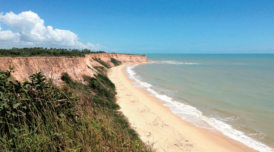
Even though there are different opinions, at least a consensus was reached: the definition of the first level taxonomy level (the most generic classification) with the major relief sets of Brazil. Scientists came to the conclusion that the first taxon would be determined by the form of relief (morphology) instead of geology (rocky substrate). Therefore, in school maps, we will find the Coastal Cliffs (a geo-environmental unit that stretches along whole Brazilian coast, from Rio de Janeiro to Amapá) being described as simply as that, and not as “Phanerozoic Sedimentary Basins and Coverings”, for instance.
Although they are not being able to work side by side during the pandemic, geoscientists keep the research flow going, aiming at the next Workshop. “Right now, specific workgroups and local collaborative groups are working hard, studying and debating in order to present their conclusions next year", concludes Ms. Botelho.


