Revista Retratos
Geographic names identify places and let us know about their history


March 13, 2019 03h32 PM | Last Updated: March 14, 2019 05h06 PM
Streets with uneven paving, made of stones*, and the colonial houses of the historical center of Paraty, a municipality in the south of Rio de Janeiro state, were the background scenery for a controversial discussion ended about ten years ago: should the name of the city be spelt with a "y” or an “i”?
It all started after changes in the spelling rules of Brazilian Portuguese led to the replacement of "y" for "i" in words such as Paraty, which from then on was spelt "Parati" in maps. Dissatisfied with the change, the residents took action to bring the “y” back to its place in the spelling of the name. That took place in 2007, after a law passed by the City Council in 2007.
The dispute shows it is not by chance that a word is pronounced differently from the way it is spelt. Each letter of phoneme carries marks of tradition of the political decisions that determine the name of things. In this respect, the names of the elements represented on a map can work as sources of information about the country. That is what the surveys about Geographic Names present. They investigate the origin and the several forms the name of a name can have, no matter if it is a city, a street, a river, relief or constructions, for example.
Seen elements of cultural heritage, the names of the several geographic features of a territory work as "linguistic fossils" with several layers of history. “The geographic name turns the space into a place, the space where one lives in, marked by emotions and having history. Whoever gives a name to a location is connecting that place to its history. By recovering the name of a construction, or by giving a name to it, one is giving it a meaning, and acknowledging its value. For that reason a name can never be disregarded" says Ana Cristina Resende, researcher from the IBGE's Cartography Department.
Each geographic name is formed by a combination of a general and a specific name. One example is “São Francisco River”, formed by the general word "river” and the specific work “São Francisco”. It is the IBGE's duty to deal with the standardization of names listed in its geographic bases. In order to do that, the institute follows the guidelines of specialists in geographic names from the United Nations (UN). Whenever it is necessary, technicians in the field interview persons to clarify doubts about a given name - spelling doubts, for example.
Name archaeology
In the case of Paraty, one of the arguments in favor of the 'y' considered the indigenous origin of the word. “It was observed that there are several different pronunciations for the indigenous 'i'. And that each one of them has a different meaning. The ‘y’ is closer to the pronunciation of something related to the territory, as if it were Paratii, which means running water. Then the linguist found it right to use the ‘y’ to represent that sound, long ‘i’, double ‘i’ ”, as explained by Marcia de Almeida Mathias, retired technician from the IBGE's Department of Cartography.
When it comes to the spelling of foreign names in the maps produced in Brazil, the professionals in charge of the standardization of geographic names must be aware of international political relations. So, spelling Malvinas or Falklands Islands in a map of South America, for example, can be seen as a sign of a political position in favor of Brazil over Argentina or of England with reference to the fight between the two countries for the ownership of those strips of land. According to Ana Cristina, a good option is to have both options in maps, although that will not solve the question. “The problem in having both names is to choose which will come first. A possible solution is to separate them with a dash to convey the idea of symmetry, but which will be the first? The alphabetical order is not proper in some cases, since translation can change the spelling of words”.
Imaginary boundaries
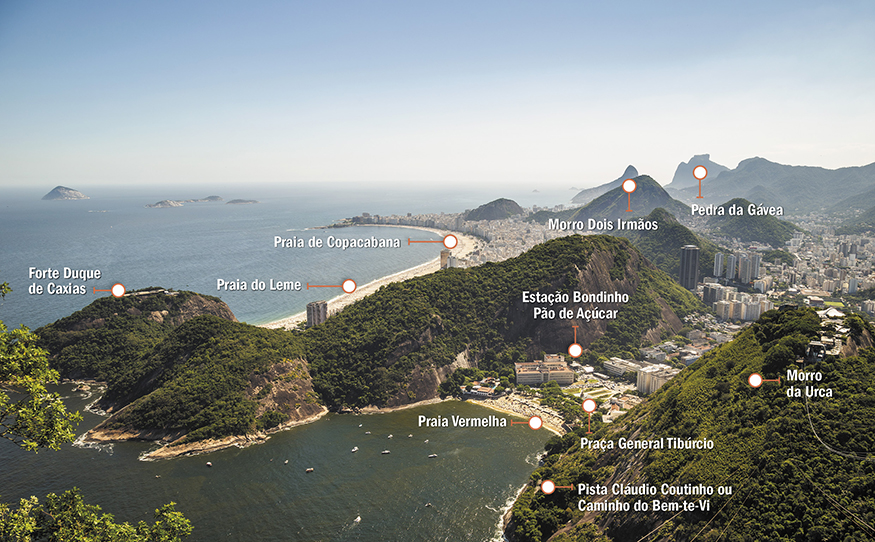
Another problem is that, according to Ana Cristina, the boundaries of a place are usually not clear for persons. There are differences between official boundaries (defined by the government) and those known by the population. The researcher mentions a difference like that in the case of Urca, as the residents of that area think that Urca is one neighborhood and Praia Vermelha, another one.
“For those who live there, in Urca, Praia Vermelha goes from the police booth outwards. Nevertheless, the whole area is called Urca, in official terms”. Marli Souza Aguiar da Rocha, a resident of Urca for more than 40 years, Praia Vermelha is a different neighborhood: “A lot of people tell me: [Urca] looks like a city in the countryside. I have heard that more than once. It is almost a side room in a house. Praia Vermelha is not so. It is further, traffic is heavier, it has got he Military Circle and Sugar Loaf. [Urca] is a small place, it's cozy”.

All the names
Each cartographic base produced by the IBGE has a list of georeferenced geographic names. According to Beatriz Pinto, manager of the Geographic Names Department, the latest maps released were those of the state of Rio de Janeiro, at the 1:25,000 scale; of Espírito Santo and Goiás, at the 1:100,000 scale; and those of Brazil at the 1:1,000,000 and 1:250,000 scales. The institute also released the Glossary of General Terms relative to names listed in the maps at the 1:1,000,000 scale. All these products are available in the download section of the IBGE website. Also according to the manager, information on geographic names is being gathered into a database. The database is expected to have many names more, so that it can be made available to external users in the future.
Read the complete article at Retratos Magazine no.16.


