Mapping of Natural Resources
Environmental Information Database is updated with new functionalities


May 28, 2021 10h00 AM | Last Updated: May 31, 2021 02h37 PM
Highlights
- Os mapeamentos de Geologia, Geomorfologia, Pedologia e Vegetação do Brasil foram atualizados no Banco de Dados de Informações Ambientais (BDiA).
- Classificações no banco de dados do mapeamento de pedologia já estão atualizadas com as diretrizes mais recentes do Sistema Brasileiro de Classificação dos Solos.
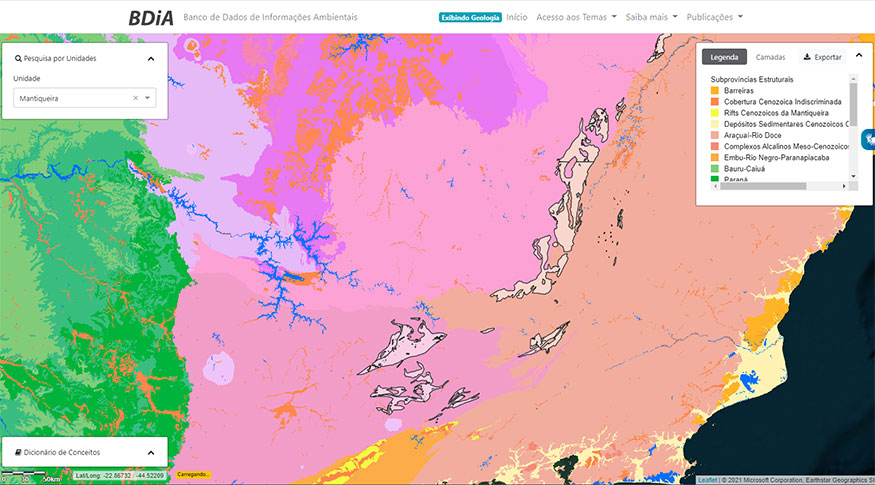
- BDiA permite visualizar Subprovíncias Estruturais como um nível do tema Geologia.
- Análise físico-químicas e morfológicas dos solos agora contam com mais detalhamento.
- Usuários contarão com mais facilidade de acesso a informações detalhadas sobre os mapeamentos.
The IBGE has released today (28), update mapping in Geology, Geomorphology, Pedology and vegetation all over brazil at Institute's platform for visualization and access to environmental geospatial to information, the Environmental Information Database (BDiA). Available since December 2018, the tool now has new data for soil analysis and some functionalities to improve user's experience with the portal, by facilitating visualization and interpretation of information.
“New material available includes data on physical, chemical and morphological analyses of the soil, derived from the RADAMBRASIL Project, besides another geological level: Structural Sub-provinces,” Marta Minussi Franco, IBGE analyst in charge of the BDiA, points out.
The analyst explains that only geologic time level (Cenozoic, Mesozoic, etc.) had been used in the database so far. Now, with the changes, it will also be possible to know more about the origin of rock formations of each sub-province.
“Structural Sub-provinces groups rocks according to their origin and evolution and are the spatial representation of geologic events related to the internal dynamics of the Earth, including the formation of continents and oceans for the last 4.5 billion years of history. For example, the sub-provinces whose rocks sustain the Mar and the Mantiqueira mountain ranges are the products of a tectonic process that involved ocean opening and closure, and the continental collision, about 600 million years ago, which resulted in the formation of the Gondwana supercontinent”, says Pedro Edson Bezerra, geologist and Natural Resources Department manager at the IBGE State Branch of Pará.
Also, the database has been updated with the latest version (2018) of the Brazilian Soil Classification System. So, BDiA is now in compliance with the most recent classifications of scientific community regarding pedology (study of the soil); in addition to that, corrections have been made in all the topics available.
In relation to the tools in the portal, innovation include links for metadata at each level of information.
“In the first version of the BDiA platform, in order to guarantee access to metadata by the user, it was necessary to access the Geoscientific Metadata system, and then search for the desired term. Now that can be done per level of information, thus facilitating understanding of the geospatial data history, as well as of the steps in the production processes and their input,” says Marta Minussi Franco, who is in of the BDiA.
About the platform:
The platform for visualization and querying at the IBGE’s Environmental Information Database is accessed by the BDiA portal. By using the tools available, the user can navigate through a topic at its different levels of classification; search for spatial information by state, municipality and biome; make queries using the name of a mapping unit; export bases as vector files (shapefile) and related statistics, information on mapping units, analyses and lists as table files (xls and pdf); look up the meaning of mapping-related terms and abbreviations from a glossary; and import other geosciences databases available in wms format.
BDiA also has a module on special query of statistical grids, which allows research from different topics related to mapping of natural resources, besides other IBGE products such as Monitoring of Coverage and Land Use, which can be consulted inter-thematically and generate statistics to support the analysis of natural resources in the country.
Spatial databases now available atBDiA are adjusted to the 1:250.000 scale and produced by the IBGE within the project Mapping of Natural Resources. Mappings derive from the interpretation of images from orbital sensors and field activities, in which specialists in different areas, such as geographers, geologists, forest engineers and agricultural engineers from the Institute, managed to represent the spatial characteristics and distribution of each one of the topics all over the National Territory.
Improvements made in thematic mapping in this new version were:
In geology (rocks)
• Update of information and descriptions of Geological Units;
• Delimitation of Structural Sub-provinces, which are subdivisions of Brazilian Structural provinces into tectonic subdomains;
• Adjustment of the initial and final ages of Geological Units, based on the International Chronostratigraphic Chart, version 2020;
• Change of the second level of visualization of the topic, from Geologic time (Era/Period) to Structural Sub-provinces
• Addition of 51,757 points with outcrops.
In geomorphology (relief)
• Revision of the Morphostructural Domain of 23 Geomorphological Units;
• Update of Geomorphological Units.
In pedology (soils)
• Update of legends in mapping units and sampling points (from the RADAMBRASIL project) according to the Brazilian Soil Classification System (SiBCS), of 2018;
• Disposability of data of physical and chemical analyses relative to the sampling points in table format (xls).
In vegetation
•450 new points of vegetation included
• 3,110 vegetation points with updated descriptive attributes
• Revision of visualization in the BDiA of Contact Areas
• Changes in BDiA titles (layers, graphs, legends, tables, surveys)
In all the topics
• Update of state and municipal subdivisions in compliance with to the Continuous Cartographic Basis scale 1:250.000, version 2019.