Territorial Structures
IBGE updates Brazil's Territorial Organization


April 29, 2025 10h00 AM | Last Updated: April 30, 2025 09h45 AM
Highlights
- The IBGE released today updates for 2024 of the Territorial Organization of Brazil. A total of seven products were released: l Digital Municipal Mesh, Brazilian Territorial Areas,Update of Municipal Maps, Brazilian Territorial Division, Municipal Toponymic Changes, Neighboring Municipalities and Municipalities in the Northern Hemisphere.
- In the Brazilian Territorial Division, a highlight was the inclusion of the municipality of Boa Esperança do Norte (MT). Thus, now the territorial organization of the country is formed by 5,569 municipalities.
- In 2024, the quantity of municipal districts reached 10,740, 19 more than in 2023. A total of new 11 new districts were found in Minas Gerais, six in Santa Catarina, one in Bahia and one in Mato Grosso, the state where three districts were excluded. The number of subdistricts was the same as in the previous year (645).
- For the first time, the IBGE presents the list of Brazilian municipalities located in the Northern Hemisphere. The update in the calculation of the country's Territorial Area in 2024 resulted in a total of 8,509,379,576 km², an adjustment of 1,038,246 km² against the figure informed in 2023 (8,510,417,822 km²).
- In the 2024 edition, the IBGE presents the maps of 190 municipalities that have gone through updates in their boundaries between May 1, 2023 and April 30, 2024.
- The 2024 version of the Municipal Toponymic Changes did not record and changes against 2023.

The IBGE has made available a group of updates related to the territorial organization of Brazil. It is the 2024 version of seven products: Digital Municipal Mesh, Brazilian Territorial Areas, Update of Municipal Maps, Brazilian Territorial Division, Municipal Toponymic Changes, Neighboring Municipalities and the latest one, published for the first time, Municipalities located in the Northern Hemisphere.
“The updates are based on cartographic updates, besides those of the new laws, legal decisions and technical reports/assessments conceived by the respective state agencies in charge of the political administrative division of each state and submitted to the IBGE,” says Roberto Tavares, IBGE's Territorial Division coordinator.
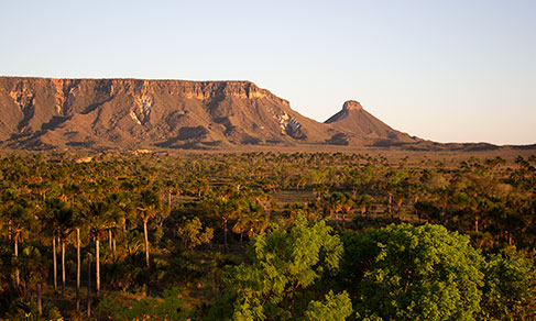
Boa Esperança do Norte (MT) is the most recently created municipality in the country
In the update of the list of municipalities, districts and subdistricts in Brazil, published by the IBGE, the municipality of Boa Esperança do Norte, in the state of Mato Grosso stands out. With an estimated population of 5,772 people, the municipality has an area of 4,704 km² and was officially installed on January 1st, 2025, in spite of having been created by State Law no. 7.264, of March 29, 2000.
The Brazilian Territorial Division (DTB) details the territorial structure of the country, and lists municipalities, districts and subdistricts. Tables with information can be found on the IBGE website.
With the inclusion of the municipality of Boa Esperança do Norte (MT), the Brazilian territorial organization in Brazil had 5,569 municipalities, one more than in the previous year. That was the first update in the number of municipalities since 2013. Added to these are the Federal District (Brasília) and a State District in Pernambuco (Fernando de Noronha).
The list presents a total of 10,740 districts. As for the list of 2023, the current survey identified the increase of 19 new municipal districts, being 11 in Minas Gerais, six in Santa Catarina, one in Bahia and one in Mato Grosso. Also, three municipalities in Mato Grosso were extinguished. The number of subdistricts, 645, has been the same since the publication of 2023.
| FU | Municipality | District |
|---|---|---|
| Bahia | Ourolândia | Alazão |
| Minas Gerais | Montezuma | Areião de Minas |
| Minas Gerais | Jequitaí | Barrocão de Jequitaí |
| Minas Gerais | São José da Barra | Bom Jesus dos Campos |
| Minas Gerais | Manga | Brejo de São Caetano |
| Minas Gerais | Carlos Chagas | Francisco Sá de Carlos Chagas |
| Minas Gerais | Carlos Chagas | Mayrink |
| Minas Gerais | Monte Sião | Mococa das Gerais |
| Minas Gerais | Monte Azul | Novo Riachinho |
| Minas Gerais | Montes Claros | Pedra Preta dos Montes |
| Minas Gerais | Jaboticatubas | São José da Serra |
| Minas Gerais | Divino | Vargem Grande do Divino |
| Santa Catarina | Florianópolis | Coqueiros |
| Santa Catarina | Florianópolis | Estreito |
| Santa Catarina | Florianópolis | Saco dos Limões |
| Santa Catarina | Florianópolis | Saco Grande |
| Santa Catarina | Florianópolis | Tapera da Base |
| Santa Catarina | Florianópolis | Trindade |
| Mato Grosso | Boa Esperança do Norte | Boa Esperança do Norte |
As part of its institutional mission, the IBGE registers the events within the Brazilian Territorial Division with the objective of updating knowledge of the country's territory to support the operational steps of data collection, processing, analysis and geographic and statistical dissemination associated to household surveys, annual population estimates, censuses and other geoscientific studies.
Brazil has 24 municipalities entirely located in the Northern Hemisphere
For the first time, the IBGE presents a list of Brazilian municipalities located in the Northern Hemisphere. Brazil has an area of 606,544,575 km² located North of the Equator, being equivalent to 7.13% of the national territory.
This part of the country is formed by 44 municipalities, distributed among the states of Amazonas, Roraima, Pará and Amapá. Of these municipalities, only 24 are entirely located in the Northern Hemisphere, with 13 in Roraima and 11 in Amapá. As for municipal headquarters, only 26 of them are in the Northern Hemisphere, all of which are in Roraima and Amapá.
The Equator runs around the center of the globe and separates the country into two hemispheres: North and South. It is where latitudes are measured from, and consists of paralell 0º. “Although a big part of the country is in the Southern Hemisphere, the Equator crosses Brazil. The launch of this new product aims at fulfilling demands of external concerning which Brazilian municipalities are above the Equator. The intention is to disseminate geographical information for the purpose of knowledge raising, education and studies of public policies for that area of the country," Roberto remarks.
The IBGE has also released today Neighboring Municipalities, which consist of a spreadsheet with the municipalities that share geographical boundaries, called neighboring, contiguous or adjoining ones.
Neighboring Municipalities and Municipalities located in the Northern Hemisphere derive from the Digital Municipal Mesh 2024, which is the basic product used by the Institute in the tabulation of all its surveys and as a spatial reference for data collection of the Population Census and the Census of Agriculture.
As for the product Municipal Toponymic Changes, the 2024 version does not have updates in the list of municipalities in comparison with that of 2023, there was no geographical and statistical changes of the IBGE, such as the National Spatial Data Infrastructure (INDE) and the Statistical Tables Database (SIDRA).
The toponyms reflect and perpetuate some of the local history and culture, by addressing a fact, a person or geographic accident of relevance during the process of occupation of a given area, or by portraying the feeling of belonging an identity of the territory. The new denomination now integrates all the geographical and statistical documents elaborated by the IBGE.
Geographic data of Brazilian states and municipalities were updated
Currently, the IBGE makes adjustments in three Geosciences products: Digital Municipal Mesh, update of Municipal Maps and Territorial Areas of States and Municipalities. The Digital Municipal Mesh is a group of digital files to represent all the Brazilian municipalities and of the estimated total area of the country. this study supports Municipal Maps and the new Territorial Area figures.
In the 2024 edition, the IBGE made available maps that had boundaries updated between May 1st, 2023 and April 30, 2024. The states with the biggest number of revisions were Rio Grande do Sul (56 municipalities), Santa Catarina (35) and Ceará (30).
Brazil's territorial area, in 2024, amounted to 8,509,379,576 km², a drop of 1,038,246 km² from the figure in 2023 (8,510,417,822 km²). The difference results from a significant improvement in the representation of international boundaries, as a result of the improvement of cartographic inputs. The new line was provided to the IBGE by the First Boundary Demarcation Commission, an arm of the Ministry of External Affairs.
According to José Henrique da Silva, manager of the Brazilian Territorial Division, "the northern border of Brazil, due to its unique characteristics, has always posed challenges concerning both the materialization of physical landmarks with adequate spacing and a cartographic production that could correctly represent the geographic features upon the borders separating Brazil from neighboring countries are based. Due to lack of more detailed and accurate cartographic inputs, the line of Brazilian borders in the region was overly simplified, in cartographic terms. Therefore, the update of such representation makes boundary lines closer to real configuration. The improvements do not mean inclusion or loss of areas."
As a result of the necessity of continuous update of the Territorial Mapping, mainly in relation to the municipal mesh, cartographic adjustments have also been made in several municipalities given the availability of ne cartographic inputs.
The IBGE keeps its technical cooperation agreement with states and Legislative Assemblies, with the purpose of consolidating the political-administrative division of municipalities, and annually receives updated based on laws, descriptions and technical reports from state agencies, which allow the monitoring of the changes resulting from the occupation of the territory and from the cartographic improvements following technological advances leading to better identification, representation and measurements of the national territory. However, in spite of the use of municipal maps as a reference for a number of activities conducted by public bodies, private agents and the society, the IBGE has no legal responsibility for the demarcation and definition of the municipal area.
The full set of documents about technical, historical and legal characteristics concerning the use of the Digital Municipal Mesh and Territorial Area figures is found in the report “Digital Municipal Mesh and Territorial Areas 2024: Technical and legal Information for the Use of Published Data,” available on the IBGE Library page.