Experimental survey
IBGE publishes study aimed at expanding the categorization of geographic spaces


August 16, 2023 10h00 AM | Last Updated: August 25, 2023 11h30 AM
Highlights
- The study differentiates the spaces of the national territory into rural, urban and includes nature as a third category in the classification.
- The three categories were subdivided into 16 types: four urban, four rural and four nature spaces, in addition to four that represent areas in transition or that mix categories with more balanced participation.
- Areas related to Brazilian capitals and the largest urban concentrations occupy only 0.4% of the territory.
- Classification into 16 types allows for a more accurate representation of the national territory
- This experimental study aims at stimulating academic and institutional debates.
The IBGE released this Wednesday (16) the study “Methodological Proposal for the Classification of Rural, Urban and Nature Spaces in Brazil”, whose purpose is to contribute to the debate on the revision of the classification of these spaces. The document, which is an experimental investigation by the IBGE based on data from the 2010 Census and other reference sources, differentiates spaces in the national territory into rural, urban and includes nature as a third category in the classification.
In addition, the three categories mentioned were subdivided into 16 types: four typically urban, four more rural and four more natural, in addition to four types that represent areas in transition or that mix two or three different categories with a more balanced participation.
“The idea producing this study was not only to renew a reference framework with the inclusion of nature, since the rural-urban dichotomy has already been well debated, but also to bring an alternative. We decided to move on from the municipal level and make this classification by weighting area, in a territorial division smaller than the municipality”, explains the manager of Regionalization and Territorial Typologies of the IBGE, Maria Monica O’Neill.
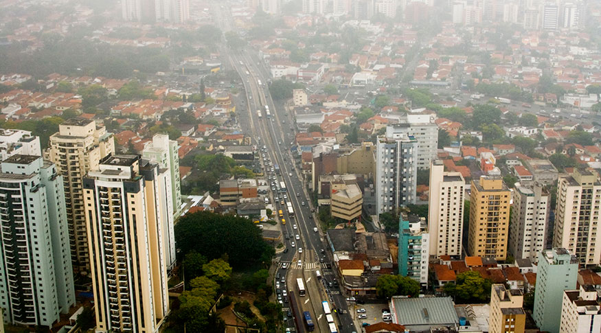
Among the types presented in the study, that of the Main Urban Areas of Large and Medium Urban Concentrations - referring to Brazilian capitals and the largest urban concentrations, with a degree of urbanization varying between 75% and 100% - occupies an area of only 0.4% of the territory. A relevant characteristic of this type is that more than 90% of its area is covered by the urbanized area and a high proportion of the employed persons are in activities considered as urban.
“I found it surprising how small the area that we consider urban in Brazil is and the fact that most of the Brazilian population is concentrated in this smallest area that we consider urban, in just 0.4% of the territory. The divisions we use can give a closer idea of what the reality of the national territory is”, highlights the researcher of the Coordination of Geography, Paulo Wagner Teixeira Marques.

Classification into 16 types allows for a more accurate representation of the national territory
The result points to some expected geographic patterns, such as the strong presence of Natural Areas in the North Region, but indicating an advance of the agricultural frontier in Rondônia, to the southeast of Pará and Tocantins, for example, showing a pattern that would correspond to the Arc of Deforestation.
In the Center-West Region, the occupation by Nature Areas is increasingly giving way to the presence of agricultural areas and Urban Areas are sparse, since urbanization is not the most active regional process there. However, the study highlights an urban axis formed by Goiânia (GO), Anápolis (GO) and the Federal District (DF), with strong spatial articulations with the country.
In the Brazilian Northeast and in the north of Minas Gerais (MG), the combination, in classes, of the three categories, Urban, Rural and Nature, outlines the presence of multivariate types. The Northeast Region has an urbanization along the coast combined with the presence of consolidated Rural Areas and articulated with large and medium-sized urban centers. In the northeastern backlands and in the north of Minas Gerais (MG), the presence of Nature Areas in transition to rural areas is significant.
Towards the south – in Minas Gerais (MG), in the triangle of Minas Gerais, Sul de Minas and Zona da Mata (MG), Espírito Santo (ES), São Paulo (SP), Rio de Janeiro (RJ) and northern Paraná ( PR) - the spatial configuration denotes, mainly, the importance of urban areas and the strong presence of rural areas linked to urban centers. The rest of the State of Paraná (PR), Santa Catarina (SC) and Rio Grande do Sul (RS), in the South region, have multivariate Rural Areas, with more consolidated agricultural activities, in addition to areas combined with the presence of Nature Areas.

Experimental study aims at stimulating academic and institutional debates
The proposed typology of predominantly rural, urban and nature spaces, in their different variations, is relevant for the formulation of public and private policies, in addition to serving as a basis for a renewal in research themes, from the point of view conceptual and relevant categories.
This study is yet experimental and exploratory, with the objective of academic and institutional discussion on the characteristics that define rural, urban and nature spaces. After being fully developed and discussed, the IBGE intends to remake the study with data from the 2022 Census, in order to provide a reference framework that will support territorial planning in Brazil.