BC100 Project
IBGE launches new Continuous Cartographic Base of Goiás and Federal District


December 15, 2022 10h00 AM | Last Updated: December 16, 2022 04h19 PM
Highlights
- The updated version of the Continuous Cartographic Base of Goiás and the Federal District (BC100_GODF) is part of the BC100 Project, which plans to map the 27 Federation Units on a scale of 1:100,000.
- The cartographic product is important for the sectoral planning of infrastructure works such as energy, transportation and communications.
- The new BC100_GODF contains an additional layer of information called the “Index of Names”, corresponding to the nomenclature of the elements that integrate it.
- In addition to Goiás and the Federal District, the states of Alagoas, Rio Grande do Sul, Sergipe and Espírito Santo are already part of the BC100 Project.
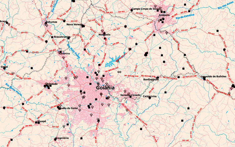
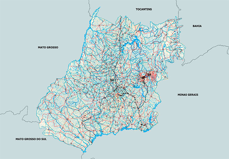
The IBGE makes available, as of today (Dec 15), the 2022 version of the Continuous Vectorial Cartographic Base of the State of Goiás and the Federal District, on a scale of 1:100,000. The release is part of the BC100 Project, which aims to map the 27 states of the federation on this scale. Goiás and the Federal District were the first states to take part in the project, the first version of which was published in 2016. The product integrates the geospatial data set published on a scale of 1:100,000, as well as the bases of Alagoas, Rio Grande do Sul, Sergipe and Espírito Santo.
The new BC100_GODF is available in free formats (Shape File, GeoPackage and PostGis database dump), for use in Geographic Information Systems and through geoservice, through the Interactive Geographic Platform.
The main applications of this database, like all the others that make up the BC100 Project, are in the sectoral planning of infrastructure works, in the development of government programs with focus on territory, in analyzes that demand a joint vision of the geographic space and as an element of spatial representation of social, economic and environmental aspects of the territory.
The 2022 version of the product includes updating the classes published in the previous version, including classes not previously mapped, in addition to updating data modeling for version 3.0 of the Technical Specifications for Structuring Vector Geospatial Data (ET-EDGV 3.0) . The mapped classes correspond to categories of information referring to the Economic Structure; Energy and Communications; Hydrography; Borders and Locations; Relief; Transportation Systems and Buildings.
"The initiatives undertaken in the integration of the area responsible for producing the cartographic base (reference mapping) with the sector responsible for mapping for census purposes are some of the innovations presented by BC100_GODF of 2022. This allowed the use of data from other projects, as well as of information produced by different surveys and collections carried out at the IBGE, adding information to the cartographic base, without disregarding the standards and norms of basic terrestrial reference mapping", highlights the technical assistant of the IBGE, Mr. Leonardo Scharth.
One of the improvements achieved, compared to the 2016 version, can be seen in the category of buildings (schools, health centers, churches, agricultural establishments, among others). There was a significant addition of features, allowing a better characterization of the mapped territory, through the representation of buildings that serve as a local reference, especially in the rural area.
“In addition to the increase of new classes not mapped in the previous version, it is possible to notice a big difference in the Hydrography and Transportation System classes. Despite exclusions, layout changes and increments, the gain in this new version was significant, mainly due to the better resolution of the reference images available for updating the cartographic base”, explains the Cartography assistant at IBGE, Ms. Fernanda Magri.
The integration of the databases also allowed the inclusion, correction and confirmation of several geographic names in several mapping classes, including names of localities and drainage sections.
“Many external administrative records were used as inputs for the mapping. An exampl is the CNES/DATASUS database for mapping health establishments, the INEP register of schools for mapping educational establishments, among many others”, adds IBGE Cartography assistant, Mr. Renato Lélis.
The product also features an additional layer of information called the “Index of Names”, corresponding to the names of the elements that integrate it. It allows to spatially locate these names, represented by dots, associated with their respective categories and classes of mapped elements. In the 2016 version, this information was presented through a textual document attached to the data set, requiring the user to perform certain operations to visualize them spatially. In this new publication, consultation is direct, as in the other layers that comprise it.
Detailed information about the cartographic base construction process is available in the Methodological Note that accompanies the product. BC100_GODF can also be accessed through the INDE (National Spatial Data Infrastructure) Geoportal and its metadata can be consulted in the IBGE Metadata Catalog.