Environmental studies
IBGE lists predominant biome in each Brazilian municipality, for statistical purposes
June 28, 2024 10h00 AM | Last Updated: June 29, 2024 01h53 PM
Highlights
- This publication, by presenting a list with the predominant biome in each municipality in the country, sets a criterion to aggregate municipal data by biome in new studies. The inter-biome municipalities, that is, those located in more than one biome, will be classified according to the predominant one – with the biggest percentage of its territory.
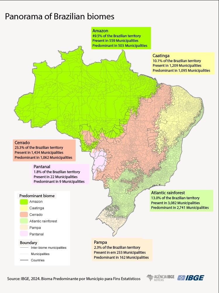
- The Atlantic Rainforest is predominant in most Brazilian municipalities (2,741), followed by the Caatinga (1,095), the Cerrado (1,062), the Amazon (503), Pampa (162) and Pantanal (9).
- A total of 963 Brazilian municipalities were considered inter-biomes (17%) and most of them are located in São Paulo.
- Four municipalities in the country are divided into three biomes: Piripá (BA), Tremedal (BA), São João do Paraíso (MG) and Cáceres (MT).
- Besides São Paulo (220), other states with most inter-biome municipalities were Minas Gerais (167), Rio Grande do Sul (141), Bahia (89) and Mato Grosso (64).
- Mato Grosso (45%), Mato Grosso do Sul (41%), São Paulo (34%), Sergipe (31%) and Rio Grande do Sul (28%) are the Federation Units with the biggest percentage of inter-biome municipalities.

Although the Amazon was the biome with the biggest area in the national territory, the Atlantic Rainforest is predominant in the biggest number of municipalities in Brazil. This is a piece of information one can find in the publication “Predominant biome by municipality, for statistical purposes,”, released today (28) by the IBGE. It informs that inter-biome municipalities, that is, the ones located in more than one biome, will be classified according to the predominant biome in terms of percentage of territorial area, when municipal data are aggregated using this criterion.
“This list is intended to make clear to users how the IBGE will aggregate data by biome in surveys that have the municipality as a survey unit. That will be done because there are municipalities located in more than one biome – inter-biomes – and we need to set a criterion for the dissemination of statistical information,” says André Assumpção, a geographer with the IBGE’s Environment Department.
The list is for statistical purposes only and will not affect in the legal definition of biomes corresponding to each municipality. That means no change will be made as for boundaries of either biomes or municipalities.
“If a given municipality is part of two biomes, that does not change the boundaries set for either the biome or the municipality. That municipality will still be part of two biomes, but, from now on, the IBGE states that, in case municipalities are aggregated by biome, that municipality will belong to biome A or biome B, and this criterion has to do with the biggest area.”
The decision was made after the topic was widely discussed by researchers. “The simplest criterion, which is that of a biome taking up the biggest territorial percentage of the municipality, was more interesting because it relates to the variety of themes the IBGE deals with, besides being easy for users to understand and reproduce.” The publication makes possible to his classification in studies about several topics that use municipal data.
Another relevant aspect is that the term inter-biome is used to identify the municipalities where a boundary line crosses the biomes, which is technical information, according to natural characteristics of the landscape. “However, the transition between biomes is gradual and there are other municipalities besides the inter-biome ones located in these areas of contact, that is areas of transition between biomes.”
Approximately 17% of the municipalities in the country are considered inter-biomes, a total of 963 – and most of them are located in São Paulo, divided between the Atlantic Rainforest and the Cerrado. Four of them are part of three biomes: Piripá (BA), Tremedal (BA), São João do Paraíso (MG) and Cáceres (MT). The other 959 are in two biomes, and most of them, in Absolute figures, is located, besides São Paulo (220), in Minas Gerais (167), Rio Grande do Sul (141), Bahia (89) and Mato Grosso (64). The Federation Units with the biggest percentage of inter-biome municipalities are Mato Grosso (45%), Mato Grosso do Sul (41%), São Paulo (34%), Sergipe (31%) and Rio Grande do Sul (28%).
Atlantic rainforest is the predominant biome in almost half of the Brazilian municipalities
The Atlantic rainforest is predominant in almost half (49.2%), that is, in 2,741 Brazilian municipalities. This biome is followed by the Caatinga (1,095), the Cerrado (1,062), the Amazon (503) and Pampa (162). Pantanal, which has an area of 151,001 square kilometers (km²) , or 1.8% of the national territory, is predominant in only nine municipalities, all of which are in Mato Grosso or Mato Grosso do Sul. The fact that there is only one municipality completely inserted in this biome, Ladário (MS), also stands out.
On the other hand, the Amazon, which represents 49.5% of the country’s territory, is seen in 559 municipalities and it is predominant in 503 of them (9.0% of the total). Other biomes that stand out in terms of dimension are Cerrado, with 1,984,554 km² (23.3% of the Brazilian territory), and the Atlantic rainforest, with 1,107,285 km² (13,0%).

The publication presents a list with the predominant biomes by municipality in a table that has names and geocodes (to identify the geographic feature) of municipalities, together with acronyms of the Federation Units where they are located.
The researcher explains that the identification of the predominant biome in each municipality can help in the identification of statistics and indicators about different topic – socioeconomic, environmental, among others.
“We hope the list presented can be a reference for the release of data about several topics by biome. The identification of the predominant biome in the municipalities is one more product aiming at the integration of data and information on several environmental and economic aspects, thus improving the analyses of the Brazilian territory to give the State and society relevant information towards sustainable development,” says the geographer.
He reinforces the importance of using this natural subdivision for the observance of geographic phenomena. “The biome, differently, from Other subdivisions, is not formed by aggregated municipalities. Its boundaries are defined by natural aspects. But the release of statistics and indicators by biome is also interesting because some phenomena can Only be observed with a change in the geography. So, for some analyses, the inclusion of environmental geographies adds to the understanding these phenomena.”
More about the survey
The publication predominant biome by municipality, for statistical purposes has a list of the predominant biomes in each municipality of Brazil, and, therefore, it sets the reference for the aggregation of municipal data in new studies in this field. With this release, the criterion adopted for inter-biome municipalities, that is, those located in two or more biomes, is the natural predominance in each territorial area. It is worth noting this is not a new delimitation of biomes, mas the adoption of a criterion for statistical purposes. Learn more about the publication reading the support material available here.


