PGI
New module of the Interactive Geographic Platform calculates road, waterway and air distances between Brazilian municipalities


December 06, 2022 10h00 AM | Last Updated: December 06, 2022 03h11 PM
Highlights
- The Reference Base for Road, Waterway and Air Distances displays routes, distances and estimated travel times between Brazilian municipalities.
- The product's target audience are users who work with large volumes of data.
- The tool can be accessed through the Interactive Geographic Platform (PGI), which has 71,000 intercity connections.
- The survey Areas of Influence of Cities (REGIC) defines the hierarchy of Brazilian urban centers and delimits the regions of influence associated with them.
- In the previous release of REGIC, tracings were in a straight line. This time, the mode (road, waterway or air) of each route is considered.
- One of the advantages of this Reference Base is the consultation of waterway travel routes.

Starting today (Dec 6th), the IBGE will make available the reference base for road, waterway and air distances. The product presents estimated routes, distances and travel times between Brazilian municipalities, according to the intermunicipal connections present in the survey Areas of Influence of Cities 2018 (REGIC 2018). Information can be accessed in a module of the Interactive Geographic Platform (PGI). This is an interactive dashboard that allows you to search, by municipality, road, waterway or air routes to other municipalities in the country among the 71,000 intercity connections of REGIC 2018.
Individual queries can be viewed or downloaded as tables or in a vector file format, as well as the entire connection route database. Unlike other digital geolocation resources that are part of people's daily lives, this reference base is not intended for the common user. Its target audience is mainly composed of users who work with a large volume of route data, as well as researchers of public accessibility policies and academics in general.
The Reference Base for road, waterway and air distances is an alternative for comparing geographic accessibility between municipalities in Brazil. The broad set of information contained in the platform is offered based on the same criteria for each mode. In addition to presenting routes, distances and travel times, one of the product's advantages is the possibility of calculating hydrographic distances, including the Amazonian municipalities where waterway transportation is predominant. These locations are often not covered by routes and distance and time estimates in other digital tools.
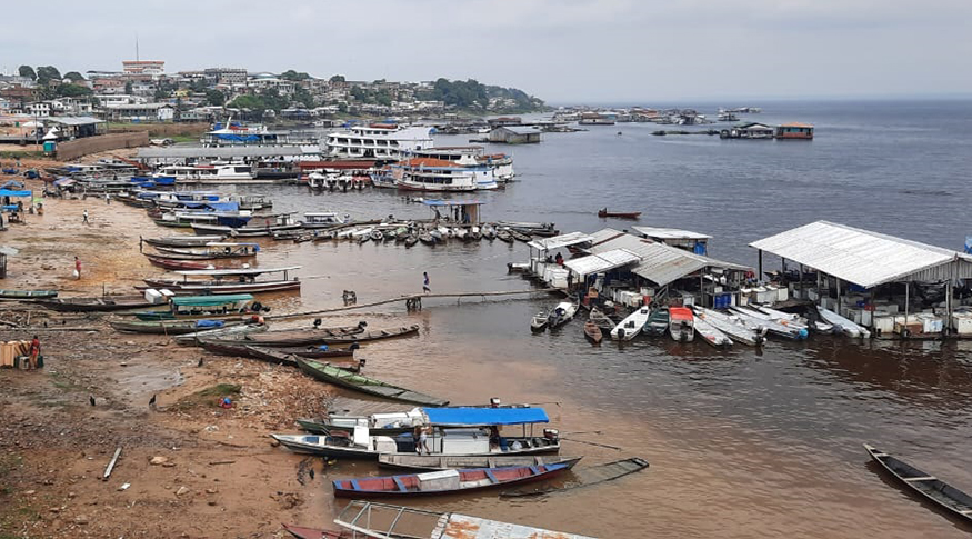 The Reference Base for road, waterway and air distances allows the calculation of hydrographic distances - Photo: Acervo IBGE
“This reference base, however, does not replace other consultation platforms, as the routes shown by it are only between municipal headquarters, that is, there is no search by address. The paths are the shortest between the pair of connected municipalities, as required by the applied model”, explains Bruno Hidalgo, IBGE manager of Geographic Networks and Flows.
For road journeys, travel time is estimated according to the road size classification. For waterway routes, the average speed of vessels used for transportation is taken into account. As a result, journey times are a proxy that can be better used when compared between routes within the base itself.
Due to the large volume of data needed to design the product, one of the biggest challenges faced was related to technological issues. “We work with a large amount of information. We are talking about more than 10 million streets, 80 thousand connections, a volume of data that takes the software processing capacity to the limit”, says Felipe Cronemberger, Geoprocessing Technologist at the IBGE.
Among the grids used for route calculations, the Open Street Maps and the IBGE Census Mapping stand out, processed according to specific criteria that can be consulted in the Methodological Note that comes with the publication.


