Environment
IBGE releases Changes in Land Use and Cover by state between 2000 and 2018


March 17, 2021 10h00 AM | Last Updated: March 18, 2021 12h40 PM
Highlights
- For the first time ever, the IBGE releases Changes in Land Use and Cover with disaggregated statistics by Federation Unit, with data for the years 2000, 2010, 2012, 2014, 2016 and 2018.
- The national data were published in 2020.
- It includes maps, graphs and technical texts that show the changes in the land use and cover of the Brazilian territory in each period.
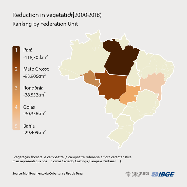
- Between 2000 and 2018, Pará registered the largest expansion in pasture areas with management and the largest reduction in areas of forest vegetation. The state had the second largest pasture area in Brazil in 2018.
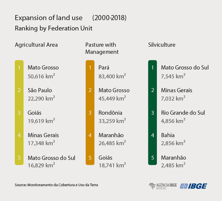
- In the same period, Mato Grosso recorded the largest area of agricultural expansion and ranked in the second position both in the increase in pasture areas and in the reduction of areas of forest and rural vegetation.
- Bahia, Piauí and Maranhão accounted for 91.74% of the increase of agricultural areas in the Northeast between 2000 and 2018, which mainly occurred on areas of rural vegetation in Matopiba (region formed by Maranhão, Tocantins, Piauí and Bahia).
- In 2018, Minas Gerais registered the largest silviculture area in Brazil, representing 22.97% of the entire national territory occupied by this class of activity.
For the first time ever, the IBGE releases today (17) Changes in Land Use and Cover with disaggregated statistics by State and Federal District, with data for the years of 2000, 2010, 2012, 2014, 2016 and 2018. The accountability of land use and cover has already been released at national level for these same reference years, being the most recent data, for 2018, released last year. The products include maps, graphs and analytical texts.
The accounting results are shown in table format, with tables of Stocks – additions and reductions, in terms of area, for the types of use and cover during a certain accounting period – and Change Matrices – conversions between different classes along a period. Mappings, which express the phenomenon in geospatial form, allow the analysis of the conversions of land use along time and space, and can be assessed in combined form with other environmental information in order to understand such evolution. The data are already available in the Interactive Geographic Platform.
"The accountability of land use and cover by states allows a more detailed analysis of the dynamics, becoming an important tool either for state managers or research institutions acting locally or regionally, since it unveils dynamics associated with the advance of agricultural frontiers, demand for inputs and expansion of livestock activities, among other related activities," explains Fernando Peres, manager of Natural Resources at the IBGE´s Santa Catarina State Unit.
Between 2000 and 2018, Pará registered the largest expansion of pasture area with management and the largest reduction of forest vegetation.
Between 2000 and 2018, Pará stood out twice among the Federation Units, with the largest absolute reduction in the area of forest vegetation (-116,086 km2), changing from nearly more than one million square kilometers to 888 thousand km2. In the same period, the pasture area with management recorded the largest expansion in Brazil (83,400 thousand km2). In 2018, the state showed the second largest area of this class of land use among the Brazilian states. A large growth of the agricultural area was also noticed, changing from 1,086 km2 in 2000 to 9,158 km2 in 2018.
The changes in the land use and cover in Pará have different characteristics in different periods: from 2000 to 2010, the conversion of forest vegetation into pasture with management was more frequent (53,419 km2). On the other hand, the advance of areas of forest mosaics over forest vegetation prevailed in the other periods under analysis: 2010-2012 (7,227 km²), 2012-2014 (3,216 km²), 2014-2016 (9,848 km²) and 2016-2018 (5,025 km²).
Mato Grosso registered the largest absolute increase of agricultural area
Between 2000 and 2018, Mato Grosso registered the largest absolute increase of agricultural area (50,616 km2) and it ranked in the second position both in the expansion of pasture area (45,449 km2) and in the reduction of forest vegetation (-71,253 thousand km2) and rural areas (-22,653 km2). In 2018, the state concentrated 17.93% of the agricultural area and 16.85% of the pasture area with management in Brazil, the largest areas of these classes of use among the Federation Units.
Observing the dynamics of the transformation of forest and rural vegetation in Mato Grosso in each period under study, the advance of pasture areas with management on forest vegetation (30,491 km2) and on rural vegetation (10,900 km2) stood out between 2000 and 2010. Between 2010 and 2012, the highlights were the conversions of forest vegetation into forest mosaics (3,584 km2) and of rural vegetation into pasture with management (872 km2).
Between 2012 and 2014, the advance of agricultural areas over forest vegetation (2,460 km2) and over rural vegetation (1,364 km2) could be noticed. Between 2014 and 2016, conversions of forest vegetation into forest mosaics (2,387 km2) and of rural vegetation into pasture with management (270 km2) stood out. And, again, between 2016 and 2018, conversions of forest vegetation into forest mosaics (2,302 km2) and of rural vegetation into pasture with management (1,447 km2) repeated.
BA, PI and MA accounted for more than 90% of the expansion of agricultural areas in the Northeast
The dynamics in the Northeast Region is marked by the expansion of areas of rural mosaics, characterized by a high number of small-sized rural establishments with multiple uses.
In the Matopiba region – acronym formed by the initials of the four states of Maranhão, Piauí, Bahia and Tocantins –, areas of rural vegetation were replaced by agricultural areas. Bahia, Piauí and Maranhão accounted for 91.74% of the increase in agricultural areas in the Northeast between 2000 and 2018, which mainly occurred over areas of rural vegetation.
In Bahia, the changes in the forest and rural covers mainly corresponded to the replacement of rural vegetation by agricultural areas and rural mosaics and of forest vegetation by forest mosaics and pasture with management. Between 2000 and 2010 and between 2010 and 2012, conversions of rural vegetation into agricultural areas (7,012 and 3,209 km2, respectively) and of forest vegetation into forest mosaics (2,755 km2 and 2,729 km2, respectively) stood out.
More recently, between 2012 and 2014 and between 2014 and 2016, conversions of rural vegetation into rural mosaics (1,775 km2 and 699 km2, respectively) and of forest vegetation into forest mosaics (947 km2 and 379 km2, respectively) stood out. Between 2016 and 2018, conversions of rural vegetation into agricultural areas (331 km2) and of forest vegetation into pasture with management (66 km2) could be noticed.
Silviculture area of MG represented more than 20% of the national total in 2018
In 2018, Minas Gerais registered the largest silviculture area in Brazil, representing 22.97% of the entire national territory occupied by this class of activity. Nevertheless, the largest increase in areas dedicated to silviculture in the 2000-2018 period was registered in Mato Grosso do Sul (7,545 km2), which involved 12.47% of the silviculture area in Brazil in 2018, the second largest area of this class of use among the Federation Units.
São Paulo represented 15.24% of the agricultural area and 11.96% of the silviculture area in Brazil, the second and third largest values among the Federation Units in 2018, respectively.