IBGE launches unprecedented map of Biomes and Coastal-Marine System


October 30, 2019 10h00 AM | Last Updated: October 30, 2019 11h58 AM
Compatible with the scale of 1:250,000, the map brings improvements in the representation of the boundaries of the Biomes and the unprecedented Coastal-Marine System, as well as updates and conceptual and technological advances. The map is the result of improvements in the investigation, bibliographic revision and inter-institutional contacts, as well as of the verification and consolidation of field surveying, which, along the boundaries between the environments under analysis, confirmed both the physical-biotic environment and evidences of the previous vegetation.
Click here to access the map.
Improvement in the Biomes Division and the introduction of the Coastal-Marine System of Brazil contribute to sustainable management of natural resources
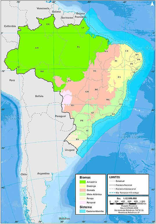
The continental biomes of the Brazilian territory — Amazon, Atlantic Forest, Caatinga, Cerrado, Pantanal and Pampa — and the Coastal-Marine System, as well as their boundaries, can be better understood with the new map in the scale of 1:250,000, released today (October 30) by the IBGE.
With techniques and criteria revised and improved, the study includes advances and contributions from institutions and professionals of several areas of natural sciences and the like – geologists, forestry engineers, agronomists, geographers and others – aiming at portraying the boundaries of the Biomes and of the Coastal-Marine System.
The publication brings valuable documents representing such boundaries, thus contributing to the sustainable management of the natural resources, from its popularization in the basic education until the support of public policies. The publication presents a chapter dedicated to each boundary between the biomes and another one to the new Coastal-Marine System, bringing methodological procedures, reasons for changing routes and relevant considerations and observations. The work is also enriched with figures and photographs of each of the six biomes, plus the new system.
The current scale, 20 times that of the previous product, brings significant differences in the boundaries between the biomes.
Study highlights Coastal-Marine System
Amazon is the biome with the largest share of the national territory, occupying 49.5%, followed by the Cerrado (23.3%), Atlantic Forest (13%), Caatinga (10.1%), Pampa (2.3%) and Pantanal (1.8%). On the other hand, the continental portion of the Coastal-Marine System occupies 1.7% of the territory, in this case overlapping the biomes.
The Coastal-Marine System has an interaction of biomes, though it is predominantly comprised by its maritime portion, being the continental portion only 6.27% of its total area. Concerning its distribution in the Brazilian biomes, most of the System (42%) is found in the Amazon biome, though impressive 25% are in the Pampa, despite its small territorial area. The Atlantic Forest biome, which has the longest shoreline in Brazil, shelters 20%.
Cerrado is present in every Brazilian region
The most extensive biome, the Amazon, occupies nearly all the North Region of Brazil (93.2%), completely encompassing the states of Amazonas, Roraima, Acre and Amapá, nearly all the states of Pará and Rondônia, and parts of the state of Mato Grosso, Maranhão and Tocantins.
The Cerrado is present in every region, though predominantly in the Central-West, where it occupies 56.1% of the territory. Its largest areas come from the states of Mato Grosso, Goiás and Minas Gerais. It should be highlighted that the Federal District is 100% included in this biome, as well as nearly all the state of Tocantins.
The Atlantic Forest biome is present in 15 Federation Units. It includes either completely or partially all the coastal states, from Rio Grande do Sul up to Rio Grande do Norte, plus the states of Minas Gerais, Mato Grosso do Sul and Goiás. It prevails in the Southeast Region: it encompasses the entire Espírito Santo and Rio de Janeiro and nearly all the state of São Paulo. In the South Region, it fully encompasses the state of Paraná and, partially, Santa Catarina.
The Caatinga occurs almost exclusively in the Northeast Region, where it occupies all the state of Ceará and it is not present only in the state of Maranhão. The only area covered by this biome out of this region is in Minas Gerais, in the Southeast.
The Pampa, in turn, is restricted to a single region and to a single Federation Unit: Rio Grande do Sul, where it covers 68.8%.
The Pantanal is the smallest biome, completely inserted in the states of Mato Grosso and, mainly, Mato Grosso do Sul.