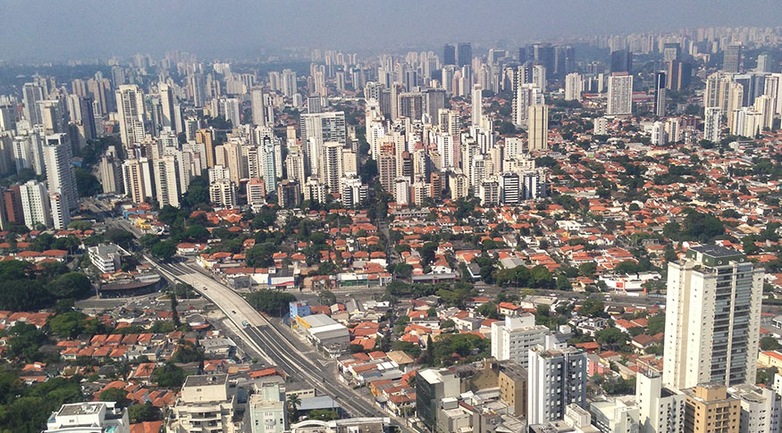
Urban spots
Southeast concentrates more than one third of urbanized areas in Brazil


November 23, 2022 10h00 AM | Last Updated: November 24, 2022 10h44 AM
Highlights
- In 2019, Brazil had 45,945 km² of urbanized areas or 0.54% of its total area.
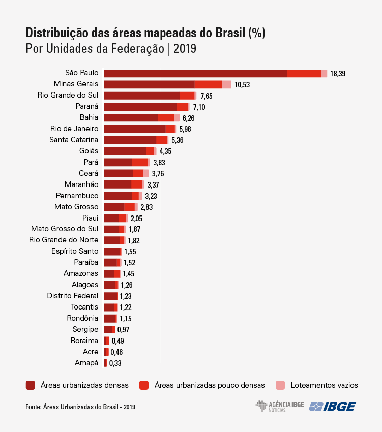
- State of São Paulo holds 18.39% of the total number of urbanized areas and empty allotments in the national territory and Amapá has the lowest number, with 0.33% of the national figure.
- Coastal municipalities add up to 19% dof the total number of urbanized areas in Brazil; in contrast, municipalities in the borderland strip hold 8% of the urbanized areas.
- Interiorization of the urbanized areas line, to a great extent, with running paths, like roads and river courses.
- Of the total mapped area, 76.5% were considered dense urbanized areas; 19.1%, slightly dense; and 4.4% were classified as empty allotments.
- Only the urban concentrations of São Paulo (SP), comprising 37 municipalities, and Rio de Janeiro (RJ), comprising 21 municipalities, are larger than one thousand km² of urbanized areas, the former with 2,133.81 km² and the latter with 1,693.80 km².
- The Northeast showed the largest absolute area of empty allotments in Brazil, with 360.53 km²; in relative terms, Ceará stood out with 11.70% of the total mapped area in the state in this category.
In 2019, Brazil had 45,945 km2 of urbanized areas, the equivalent to 0.54% of the Brazilian area. More than one third (36.5%) of the Brazilian urbanized areas is concentrated in the Southeast Region. It is unveiled in the Urbanized Areas of Brazil 2019 study, made from visual interpretation of satellite images, having 2019 as the reference year and published today (23) by the IBGE. Mapping enables to portray and measure the distribution and extension of the urban spots in Brazil, as well as assess their expansion.
“If, on the one hand, all the Brazilian urbanized areas fit in the state of Espírito Santo, on the other hand, the sum of the Brazilian urbanized areas is higher than entire countries, like Denmark and the Netherlands,” compares Manuela Alvarenga, IBGE manager of Land Use and Cover.
Of the 27 Federation Units, 14 had less than one thousand km2 of urbanized areas in 2019. For this study, urbanized area is every contiguous spot that shows an agglomeration of households, streets and other buildings sufficiently close to each other that allows neighborhood relations and daily exchanges.
The state of São Paulo holds 18,39% of the total number of urbanized areas and empty allotments (areas with street layouts, either without households or with few isolated households) of the national territory, adding up to 8,614.62 km2. On its turn, Amapá is the state with the smallest absolute area, adding up to 151.22 km2 of urbanized areas and allotments, which represents 0.33% of the national figure.
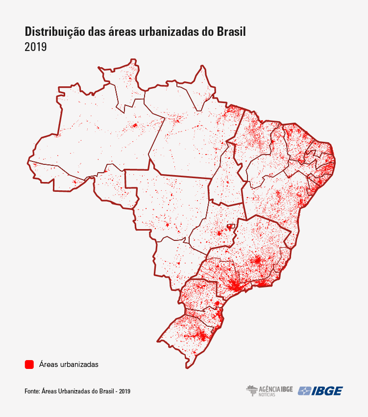
“The urbanized spots in Brazil are very concentrated and they aggregate around themselves or run alongside an existing infrastructure, like a road, for example,” explains Alvarenga. “Following the historical pattern, the general distribution of urbanized areas in Brazil is concentrated in the shoreline,” completes the geographer.
In the 443 coastal municipalities, which occupy 5% of the official area of the national territory, there is an extension of 9,166.79 km2 of urbanized areas, nearly 19% of the total number of urbanized areas in Brazil. In contrast, along the municipalities in the borderland strip, which add up to an extension of 2,265,046.64 km2 (nearly 27% of the territory), there are 3,803.20 km2 of urbanized areas (nearly 8% of the national figure). In these cases, the concentrations are located in the borderland strip of the South Region and of the state of Roraima.
Even so, the interiorization of the urbanized areas occurs, lined, to a great extent, with running paths, like roads and river courses, which is reflected in the form of multiple urban spots. Examples of this phenomenon are the urban concentration of São José dos Campos (SP), lined with BR-116 Highway (President Dutra), and the urban concentration of Imperatriz (MA), lined with BR-010 Highway (Belém-Brasília) and with Tocantins River.
Federal District has 94.59% of urbanized areas classified as dense
The study also took into account the density proportions, dividing the urbanized areas studied as either dense or slightly dense, as well as it registered empty allotments. The last category began to be observed in the current edition of the mapping, and it does not represent a consolidated urbanized area, but rather an urbanization trend. They are changed by anthropic actions, presumably destined to be urbanized areas, with well-defined and delimited street layouts, though without buildings or with an insufficient amount to be classified as a slightly dense urbanized area.
Of the total area mapped (48,052 km2) in Brazil, 76.5% were considered densely urbanized (spots of continuous urban occupations with closer buildings, with few empty spaces and large capillarity of roads); 19.1%, slightly dense ones (buildings far from each other, typical of areas being occupied in the outskirts of cities or located far from urban centers); and 4.4% were classified as empty allotments.
“Wherever there are denser areas, the trend is also to have more slightly dense areas, because they are phenomena associated with the urban expansion,” comments Alvarenga. Most states follow a pattern of average distribution between 70% and 80% of dense areas and 20% and 30% of slightly dense areas, except for, on the one hand, Piauí, Amazonas, Pará, Acre and Roraima, which have more than 30% of their urbanized areas classified as slightly dense and, on the other hand, Paraná, Rio de Janeiro, Espírito Santo and Federal District with more than 85% of their urbanized areas classified as dense. In the case of the DF, that proportion hits 94.59%.
Empty allotments have more variable distributions. However, in the analysis by Major Region, it is possible to notice that the highlight is the Northeast Region, with 826.19 km2 of areas of empty allotments, exceeding by more than 100 km2 the region ranked in the second position, the Southeast, with 646.18 km2 of such areas. The highlights are the states of Ceará (11.70%), Pernambuco (8.74%) and Piauí (8.49%), showing the highest proportions of empty allotments in the total number of mapped areas. “It can point out a trend of recent urban expansion in these Federation Units, it is required to check it in the next editions of the mapping,” argues Alvarenga.
State capitals dominate ranking of urbanized areas
Among the large urban concentrations, those with the population above 300 thousand inhabitants, which comprise the largest urbanized areas in Brazil, the highlights are in the regions of the state capitals, though with some exceptions, especially in the state of São Paulo, such as the urban concentration of Campinas (SP) which, with 492.49 km2 of urbanized areas, is among the ten largest ones in Brazil. Urban concentrations are population arrangements or isolated municipalities with a population above 100 thousand inhabitants that show a high degree of internal integration and significant conurbation, among other characteristics.
Only the urban concentrations of São Paulo (SP), comprising 37 municipalities, and Rio de Janeiro (RJ), comprising 21 municipalities, have extensions larger than one thousand km2 of urbanized areas, the former with 2,133.81 km2 and the latter with 1,693.80 km2. Currently comprising 18 municipalities, the urban concentration of Curitiba (PR) was the one that mostly grew in absolute terms (185.58 km2) between the reference years of 2015 and 2019, an increase of nearly 32% in its urban spot. It is worth reminding that the edition with the reference year of 2015 used satellite images from 2011 onwards, according to inputs available at that time.
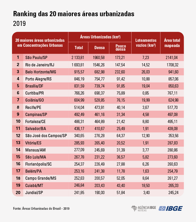
Among the medium urban concentrations, those with a population between 100 thousand and 300 thousand inhabitants, Jundiaí (SP), with 241.84 km², and Ribeirão Preto (SP), with 188.97 km², were those with the largest areas. São José do Rio Preto (SP) is another highlight, with 178.49 km², one of the largest in Brazil. Uberlândia, in Minas Gerais, is an medium urban concentration in an isolated municipalities, standing out with 172.85 km² of urbanized areas.
Among the 185 medium and large urban concentrations in Brazil, compared with the previous edition of the study with the reference year of 2015, most of the urbanized areas (95.38% of the total number of areas in 2015) did not suffer any change (19,095.90 km2). Concerning the changes, the addition of urbanized areas was the most frequent one (3,929.56 km2), representing a growth of nearly 19% of them in the period, followed by densification (531.40 km2) in 2.65% of the area mapped in 2015.
“It points out a continued expansion of the urbanization phenomenon in Brazil. Undensification and subtraction processes did not occur in significant areas,” observes Alvarenga, adding that the mapping of urbanized areas is one of the key variables to understand the urban phenomenon. “Associated with information for population, environment, economy, circulation and networks, among others, it shows a great potential for urban planning in Brazil,” concludes the geographer.