New IBGE publication discusses territorial dynamics of sugarcane


December 22, 2017 10h00 AM | Last Updated: December 28, 2017 11h43 AM
The IBGE released today the Geography of Sugarcane, a publication that discusses the territorial aspects of the sugarcane economy. The sources of inputs and agricultural machines, crop areas, distribution of sugarcane and derivatives and places of industrial processing and trading are analyzed. This publication is the second volume of the Territorial Dynamics of the Agricultural Production series.
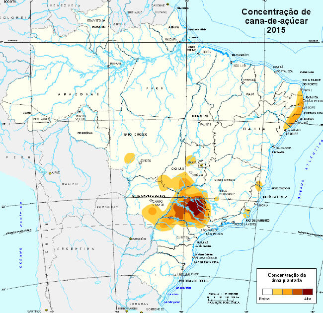
Although the Atlantic Forest is still the biome in which sugarcane prevails, the planted area in the Cerrado significantly increased over the last decade. As a result, the Cerrado in the state of São Paulo, which represents only 1% of the national territory, concentrates not less than 1/3 of the entire crop area of sugarcane in Brazil. Nevertheless, sugarcane fields are present in every Federation Unit, feeding a number of enterprises and manufacturing methods, from cattle fodder to manufacture of paper.
The spatial analysis in this volume uses statistical data produced by the IBGE – like the Municipal Agricultural Production - PAM and Central Register of Enterprises - Cempre – and by other official sources, like the Ministry of Agriculture, Livestock and Supply and Ministry of Industry, Foreign Trade and Services. This information is also available in the Interactive Geographic Platform - PGI in the form of layers of geospatial data. The complete publication is here.
The first chapter of this study discusses the biology and ecology of sugarcane, dealing with natural variables – for example, amount and seasonality of rainfall – and aspects related to the infrastructure and inputs added by farmers – like certified molts and irrigation. It also provides subsidies to assess the recent expansion of sugarcane in different Brazilian biomes, highlighted by the expansion of the planted area in the Cerrado in the state of São Paulo over the last decade.
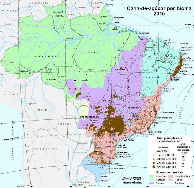
The second chapter introduces the social and economic aspects of this crop between 1975 and 2015. In the long term, the major change noticed was the retraction of traditional areas in the Northeastern shoreline and in the north of Rio de Janeiro, and the expansion in the Cerrado biome, from the consolidated modern area of Ribeirão Preto (SP). From this core, sugarcane crops continuously expanded to the west-southwest, towards the plateaus of the Paraná River, including the Minas Gerais Triangle, the center-south of Goiás and the south of Mato Grosso do Sul.
The third chapter describes the geography of the industrial processing of sugarcane, including its major derivative products, like the production of panela, molasses and brown sugar, from the production of spirits – either handcrafted or industrial – to the large modern industry of sugar and ethanol.
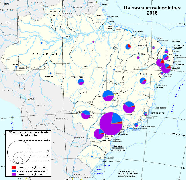
The analysis shows that the Southeast Region concentrates the output of sugar, ethanol and energy and has the biggest number of plants. Besides the spatial configuration of the production of panela, molasses, spirits, sugar and ethanol, this chapter discusses the geography of the use of bagass to generate energy in thermal power plants. Another subject is the current development of derivative products like the "second-generation ethanol" - SGE and "green plastic", produced from sugarcane ethanol.
The fourth chapter describes the distribution of sugarcane derivatives – including infrastructure and logistics – and levels of regional consumption by families, as well as exports. This part of the study shows how the recent growth of the sugar-energy sector reflected in new challenges for delivering sugar and ethanol to the public, as well as reflects on the positioning of sugarcane derivatives in the Brazilian and world market.
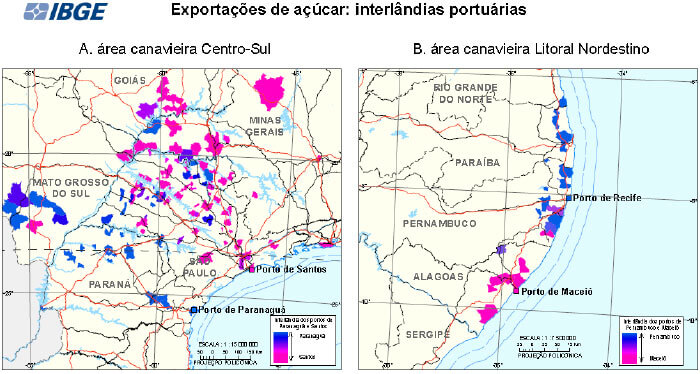
An exercise on the regionalization of the port Hinterland – geographic area served by a port and linked to it through a transportation network – related to the distribution of sugar and ethanol from Brazil to abroad is also made. It unveils that the sugar Hinterland of the Port of Santos and of the Port of Paranaguá overlap, though Paranaguá influences the state of São Paulo.
The fifth chapter introduces the production and circulation chains under the point of view of the centralities generated by the location of enterprises and educational and research institutions, and by the intercity flows of raw materials and inputs. By means of the integration of area data – place attributes – and flow data – relations between places –, this chapter provides an unprecedented analysis of the spatial circuits that structure the Brazilian sugar-energy economy.
These analyses point out two major regional sugar-energy sites: in the Northeastern shoreline and in the Paraná River basin – understood in the geological sense, i.e., a sedimentary basin. These two sites comprise different combinations of physical and human facts, being different in terms of agricultural productivity, level of input use, logistical structures and structure of spatial circuits, among other characteristics.
