IBGE releases new version of Physical Map of Brazil


December 13, 2017 10h00 AM | Last Updated: December 13, 2017 11h05 AM
The IBGE releases today the first version of the Physical Map of Brazil in the 1:2,500,000 scale (1 cm = 25 km). Comprising physical aspects of the terrestrial surface of the Brazilian territory, the map is a cartographic representation that brings information on altimetry and physiographic elements of Brazil, like mounts, hills, peaks, mountains and water bodies. The map also shows the political-administrative organization of the national territory, including the 26 states and respective capitals, as well as the Federal District. The PDF version of the map can be accessed here.
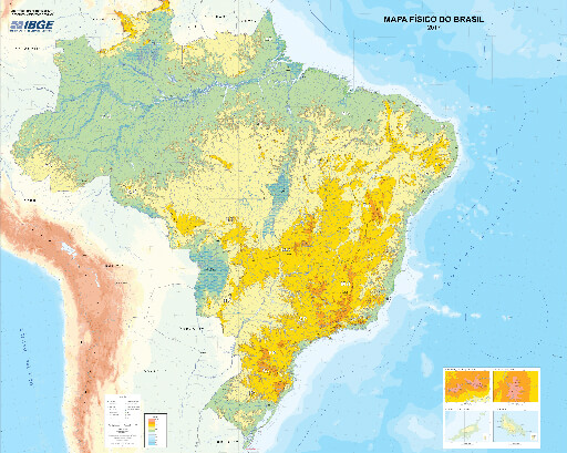
Available in the printed and digital formats, the map pinpoints the Brazilian river macro-basins and the major structures of the relief. Due to its large dimension (1800 mm x 2250 mm), the map is divided into four parts to facilitate its printing and handling.
The map was designed from the 2016 version of the Continuous Cartographic Base of Brazil in the 1:1,000,000 scale. A system of grading hypsometric colors – a technique that represents the heights of a terrain through colors – was used to represent heights. In the new edition, green represents the lowest height and magenta, the highest heights.
