IBGE releases up-to-date version of the National Digital Atlas of Brazil 2017


June 28, 2017 10h00 AM | Last Updated: July 04, 2017 11h16 AM
The National Digital Atlas of Brazil 2017 updates the sections "Brasil no mundo" (Brazil in the world) and "Sociedade e economia" (Society and economy) and brings a new section on "Cidades Sustentáveis" (Sustainable Cities). By means of interaction, this publication includes the information comprising the National Atlas of Brazil Milton Santos, published in 2010.
The 2017 edition of the National Digital Atlas of Brazil unveils the deep changes in the Brazilian geography, following up current changes in the occupation of the national territory. It is structured along four major themes: Brazil in the world; territory and environment; society and economy; and geographic networks.
In addition to text, the Atlas uses maps, tables and graphs to provide a comprehensive match of statistical data and geographic terrain surfaces, making it easier to understand the demographic, social, economic, environmental and cultural diversity of the Brazilian territory.
Click here to see the National Digital Atlas of Brazil 2017.
Geography of sustainable cities in Brazil
This section makes a spatial approach of a number of information produced by the IBGE and other public institutions on sustainability in its urban dimension, as a way to support the discussions about the Sustainable Development Goals 11 (SDG11): "make cities and human settlements inclusive, safe, resilient and sustainable".
This section is structured around four themes: urbanization, housing and urban mobility; urban environment and safety; planning, democratization and participation in society; and culture and heritage.
Socio-spatial inequalities
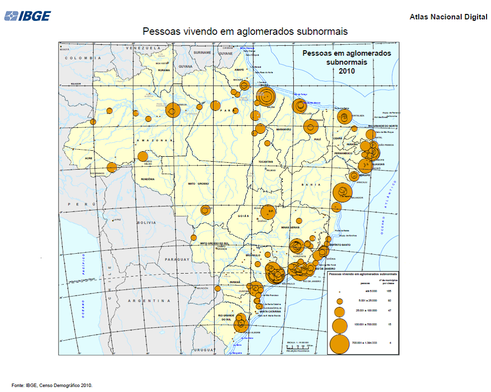
The maps below are examples of how the Atlas approaches subjects, like those related to Housing in Brazil. It allows the visualization of socio-spatial inequalities, which mark, on the one hand, the distribution of residents in subnormal agglomerates and, on the other hand, the spatiality of residents in appropriate housing units.
In this regard, the map below shows that, in spite of subnormal agglomerates – places with irregular tenure and precarious access to basic urban services – are not restricted to major cities, they are more significant there. As a result, the spatial pattern of the map on persons living in subnormal agglomerates unveils that all the Brazilian capitals have a high percentage of inhabitants living in those places.
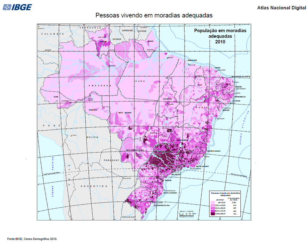
According to the IBGE classification, appropriate housing units are those that water is supplied by a distribution network, sewage is drained by a sewage or rain network or by a septic tank, and garbage is directly collected by a sanitation service or a dumpster of a sanitation service.
Therefore, the map below highlights that the biggest proportion of the population living in appropriate housing units (75% or more) are concentrated in the most dense urban area in Brazil. The west of São Paulo registers such percentages. The capitals of the states of the Southeast and South also stand out, as well as the Federal District. In the other end, the smallest proportion of the population lives in appropriate housing units in the North and Northeast Regions, including the capitals.
Application allows browsing in interactive environment
The National Digital Atlas of Brazil 2017 is an application of geographic analysis for users who would like to access the maps only and also for those more advanced users looking for online geographic information.
The application accesses all the pages of the Atlas, downloads and queries geographic and statistical data, and metadata (information on the data). Users can browse through the maps, change scales, check and export tables and graphic files, customize maps superimposing themes from different sources, generate images, save the study environment for further analysis and open a customized study environment.
Users have access to all the pages of the publication and can download these pages and check the metadata for a better understanding. The application allows more advanced users to analyze maps in an interactive environment.
For every theme of the Atlas the associated metadata is provided. All the themes are found as geo services and can be exported in other formats. The application provides the temporal visualization of some themes, thus allowing the analysis of changes over the years.
Atlas is organized around four major issues
The theme "O Brasil no mundo" (Brazil in the world) approaches issues like social inequality, access to information, geographic networks and energy sources.
The relation between "Território e meio ambiente" (Territory and environment) emphasizes the different divisions of the Brazilian territory and includes maps of relief, climate, soil, hydric resources, vegetation and endangered fauna, as well as information on environmental risks.
The theme "Sociedade e economia" (Society and economy) approaches geographic dynamics, urbanization, social inequality, health, education, sanitation, citizenship and economic space.
The theme "Redes geográficas" (Geographic networks) considers systems and networks – geodetic, cartographic, roads, communication and energy – as components of the territory logistics and, therefore, of the geographic localization of the economic activities in Brazil.
