IBGE releases WEB version of the Geographic Atlas of Brazil’s Coastal and Oceanic Zones


June 30, 2017 10h00 AM | Last Updated: July 04, 2017 10h58 AM
The IBGE releases today the WEB version of the Geographic Atlas of Brazil’s Oceanic and Coastal Zones. This new version, produced in partnership with the Interministerial Commission for Sea Resources (CIRM) is directed to students and the public in general, and presents information about the ocean and the Brazilian seashore, encompassing its historic, demographic, economic, social, cultural and natural aspects.
The interactive digital Atlas includes all the information presented in the printed version, published in 2011. The objective is to stimulate thought so that the society can acknowledge the importance of a rational use of biodiversity and of the mineral and energetic resources available in ocean waters, in the marine soil and subsoil. Those constitute essential elements for socioeconomic development and environmental sustainability in the country, as stated by SDG no “Life below Water” which deals with the conservation and sustainable use of oceans, seas and marine resources aiming at sustainable development.
Application allows interactive navigation
The new version gives the user access to an assortment of more than 120 maps and to databases. One can download and access geographic and statistical data, and also analyze maps, navigate, change the scale for visualization and export of tables and graphs, customize maps, generate images and save the material.
Source: IBGE, Diretoria de Geociências, Coordenação de Geografia
The Atlas structure consists of seven themes. “The sea in Brazilian history” highlights the expansion of the Portuguese crown and the importance of the sea in the organization of space in Brazil. “Geopolitical map of Brazil” deals with the relative position of Brazil in the Atlantic and in South America, with a focus on its boundaries of Territorial sea, Contiguous zone and Exclusive economic zone.
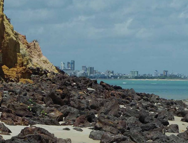
Ponta do Seixas, in João Pessoa (PB), is the most extreme point in Eastern Brazil
Photo: Marco Antônio de Carvalho Oliveira
“Geological evolution of oceans” provides details about the origin and tectonic structure of ocean basins, and some results of recent surveys about the Brazilian continental platform, and about the potential use of its mineral resources. “Oceanographic characteristics” present and overall view of these phenomena in the Atlantic, which are relevant to explain matters related to the environment, coats and seas in Brazil.
“Coastal and marine ecosystems” calls attention to the diversity of coastal and marine environmental in our country, with a focus on areas of conservation and sustainable use of ecosystems. “Diversity of Brazil’s seashore” presents maps of 14 areas in the coast, encompassing different environments and four maps of both ocean islands and the distribution of urban areas over the Brazilian seashore.
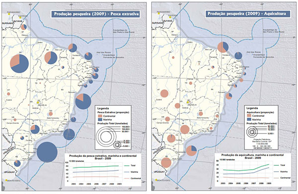
The last theme, “Cross-sectoral issues in the study of coastal environments” deals with a number of socioeconomic aspects and their relationship with those environments. This theme approaches the topics populations, tourism, bathing water quality, fishing resources, port structure, oil logistics and areas for environmental preservation and protection.
