Regional Maps
IBGE updates municipal borders in Legal Amazon Map


June 16, 2021 10h00 AM | Last Updated: June 17, 2021 10h03 AM
Highlights
- The Legal Amazon occupies 5,015,068.18 km² of land, or about 58.9% of the Brazilian territory.
- Changes in relation to the previous map occurred in the inner cities of the region, without changes in state and international borders.
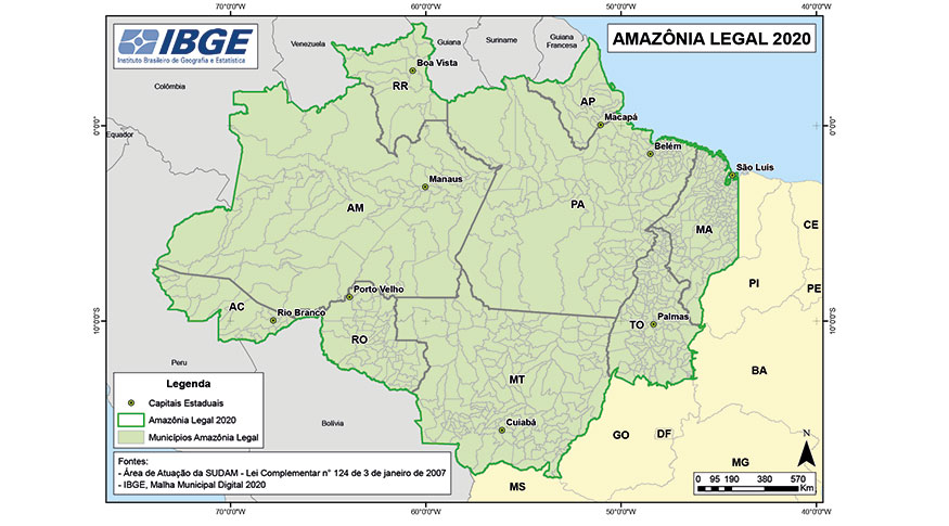
The IBGE releases today (June 16) the 2020 Legal Amazon Map, based on the update of the Municipal Mesh. The map brings the state and municipal borders, as well as the positioning of the cities' headquarters in order to broaden the understanding of the urban dynamics and the logistic infrastructure of regional integration.
Currently, the Legal Amazon occupies 5,015,068.18 km² of land, corresponding to nearly 58.9% of the Brazilian territory (8,510,295,914 km²).
“The biggest changes compared to 2019 were in the inner municipalities of the Legal Amazon”, comments IBGE cartographer Diogo Nunes. This is because there were no updates in the representation of Brazil's borders with other countries, nor changes in the boundaries between the states that make up the area. “For example, in Mato Grosso, the municipality of Várzea Grande had changes in its territory, but that did not change the total area in question”, adds Mr. Nunes.
The new map also brings elements to support analysis of Intermediate Cities in the Legal Amazon, those with socioeconomic characteristics and connections capable of consolidating and disseminating local and intra-regional development, based on the Amazon urban network, its flows and road and river connections.
The updating of the Legal Amazon territorial area is a reference in the combination of statistical and geoscientific information. It can contribute to build a solid database to support regional planning and enable the monitoring of social and regional inequalities and of the sustainable development goals.
Established by law in 1953, the Legal Amazon defines the geopolitical delimitation of the area for the purpose of social and economic planning of the region, and "The federal government is responsible for demarcating the Legal Amazon, whereas the IBGE, for the dissemination of the region's area", explains Mr. Nunes.
Currently, nine states make up the Legal Amazon: Acre (22 municipalities), Amapá (16), Amazonas (62), Mato Grosso (141), Pará (144), Rondônia (52), Roraima (15), Tocantins (139) and part of Maranhão (181 municipalities, of which 21 were partially integrated), with a total of 772 municipalities. Maranhão is the state with the largest number of municipalities in the area and has 79.3% of its territory (or 261,350,785 km²) integrated into the Legal Amazon.
Historical context
Initially established in 1953 by Law 1806, the Legal Amazon comprised the states of Pará and Amazonas, the federal territories of the time, of Acre, Amapá, Guaporé and Rio Branco, and also part of Mato Grosso to the 16th parallel north, the portion of Goiás to the 13th parallel north and the Maranhão area to the 44th meridian west.
In 1966, Law 5,173 defined that the region would cover the states of Acre, Pará and Amazonas, the federal territories of Amapá, Roraima and Rondônia, and also the areas of Mato Grosso to the 16th parallel north, of Goiás to the 13th parallel north and Maranhão to the 44th meridian west.
In 1977, Complementary Law 31 of October 11, 1977 included the entire state of Mato Grosso to the Legal Amazon.

 Related Products