Tide Gauge Network
Study brings data from sea level monitoring by IBGE stations


December 16, 2021 10h00 AM | Last Updated: December 17, 2021 12h10 PM
Highlights
- Publication brings data from the monitoring of sea level from July 2001 to December 2020.
- Information is useful for ports and waterways, infrastructure of coastal areas and studies on the impacts of global sea level rise.
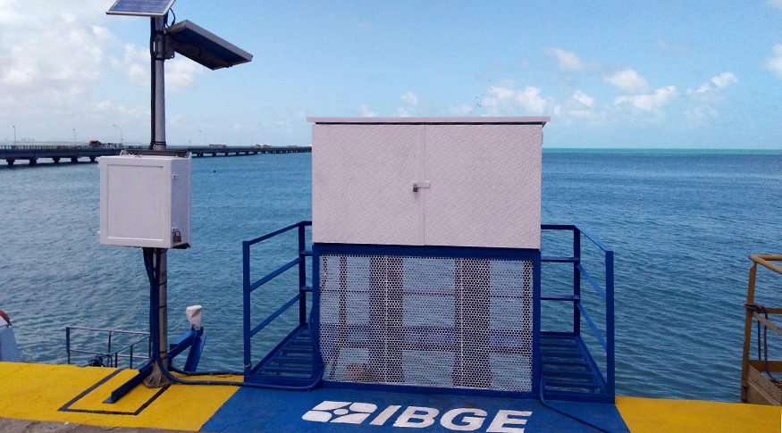
- The Tide Gauge Network currently has six active stations, with modern collection equipment, installed at strategic points along the Brazilian coast.
- Study is aimed at students and professionals in the field.
The IBGE makes available today (16) a publication with the results of the monitoring of the variation of the mean sea level in the stations of the Geodetic Permanent Tide Gauge Network (RMPG), obtained from July 2001 to December 2020. The study is aimed at students and professionals in education, engineering, coastal management, public management and scientific studies.
Made up of a set of tide gauge stations, installed and operated by the IBGE, the RMPG monitors the relationship between the vertical datum, which is the official reference surface formed by mean sea levels, and other tidal reference levels used in nautical cartography and coastal engineering. These data support studies on the modernization of Brazilian heights and the variation in mean sea level.
In Brazil, the two vertical origins (vertical datum) are based on tide observations from the stations of Porto de Imbituba, in Santa Catarina (1949-1957), and Porto de Santana, in Amapá (1957-1958).
"Monitoring the sea level is essential for the development of activities inherent to coastal management, environmental studies, monitoring and warning of extreme events, among other aspects related to the topic", exemplifies the Vertical References manager of the IBGE Coordination of Geodesy and Cartography, Mr. Salomão Soares.
The information produced by the RMPG stations is useful, for example, for conservation and expansion of the capacity of ports and waterways, implementation of infrastructure in coastal areas and the study of possible adaptation measures and mitigation of the impacts of the global rise in sea level. Internationally, it contributes to the Global Sea-Level Observation System and the Caribbean Tsunami Warning System.
The publication Monitoramento da Variação do Nível Médio do Mar nas Estações da Rede Maregráfica Permanente para a Geodésia (Monitoring the Change in Mean Sea Level at Stations of the Geodetic Permanent Tide Gauge Network) provides a current overview of the RMPG, detailing its latest innovations and procedures for the treatment and analysis of data collected by the stations. These results, added to the information from the geodetic control of the stations, provide consolidated time series with their respective updated level correlation sheets.
Modern stations measuring sea level
Since the last study published by the IBGE on the subject, in 2016, the RMPG has undergone profound changes in order to meet the current demands for continuous monitoring of sea level variation, with high quality information.
This led to the expansion of the network, which today has six active tide gauge stations, with modern collection equipment, installed at strategic points on the Brazilian coast: in Imbituba (SC), Arraial do Cabo (RJ), Salvador (BA), Fortaleza (CE ), Belém (PA) and Santana (AP). The Macaé station, in Rio de Janeiro, has been inactive since 2015, due to the end of an agreement with Petrobras.

In addition to the modernization of the network, stricter geodetic control methods were applied in the period, which comply with the fundamental requirements of modern Geodesy, as recommended by the Intergovernmental Oceanographic Commission of UNESCO. Thus, the monitoring of temporal and spatial evolutions of Brazilian vertical references and their relationships with other reference levels used in the country's coastal area are guaranteed with continuous and long-term information on the mean sea level.
The publication is available on the IBGE website, which also provides the time series of tide gauge stations, published annually, and the updated level correlation sheets for these stations, with the inclusion of the geocentric connection and the files of their respective harmonic constants, considered essential for annual forecasts.