IBGE discloses Monitoring of Land Use and Land Cover of Brazil for 2016


November 12, 2018 10h00 AM | Last Updated: November 16, 2018 01h23 PM
The IBGE today discloses the Monitoring of Land Use and Land Cover of Brazil for 2016, expanding the time series that already covers the years 2000, 2010, 2012 and 2014. The objective of the work is to monitor the territory dynamics and its occupation, through a spatial and quantitative monitoring of plant cover and land use all over the country. With the exception of the 2000 - 2010 decade, this study has been carried out by the IBGE every two years.
The results of this work are found in the IBGE website and in the Interactive platfrom, in statistical grids with details for each km² of the Brazilian territory.
Between 2014 and 2016, more than 62 thousand square kilometers of the Brazilian territory suffered some type of change in land cover and use. As a whole, the reduction of areas of natural vegetation and the expansion of agricultural and forestry areas go on, but at a slower pace compared to previous periods (2000-2010, 2010-2012 and 2012-2014). Managed pastures continue to advance, especially on the edge of the Amazon biome. In some regions, there was an increase in the agricultural area, as in the southeast portion of Rondônia, on the border with Mato Grosso; in the region of Paragominas (PA); between the municipalities of Campo Grande (MS) and Cassilândia (MS); and in the Campanha Gaúcha (RS).
| INVENTORIES / CLASSES |
Artificial Area | Agricultural Area | Managed Pasture | Mosaic of Occupation in Forests | Silviculture | Forest vegetation | Humid Areas | Grassland vegetation | Mosaic of Ocupations in Grasslands | Inland Water Bodies | Coastal Water Bodies | Bare Land |
|---|---|---|---|---|---|---|---|---|---|---|---|---|
| Inventory (2000) | 34,567 | 458,975 | 885,186 | 847,721 | 50,543 | 4,017,505 | 34,297 | 1,834,153 | 234,729 | 128,749 | 222,461 | 3,680 |
| Increase | 1,650 | 99,400 | 237,614 | 81,785 | 21,535 | 1,617 | 104 | 1,219 | 18,632 | 0 | 0 | 19 |
| Decrease | 0 | 2,143 | 23,769 | 98,645 | 2,234 | 216,404 | 115 | 109,588 | 10,673 | 0 | 0 | 4 |
| Inventory (2010) | 36,217 | 556,232 | 1,099,031 | 830,861 | 69,844 | 3,802,718 | 34,286 | 1,725,784 | 242,688 | 128,749 | 222,461 | 3,695 |
| Increase | 513 | 28,329 | 36,210 | 24,164 | 8,310 | 722 | 62 | 723 | 10,285 | 0 | 0 | 8 |
| Decrease | 0 | 793 | 9,135 | 24,367 | 2,083 | 36,610 | 140 | 32,570 | 3,621 | 0 | 0 | 7 |
| Inventory (2012) | 36,730 | 583,768 | 1,126,106 | 830,658 | 76,071 | 3,766,830 | 34,208 | 1,693,937 | 249,352 | 128,749 | 222,461 | 3,696 |
| Increase | 731 | 42,328 | 22,634 | 15,303 | 6,566 | 1,950 | 206 | 1,447 | 6,092 | 0 | 0 | 4 |
| Decrease | 0 | 1,464 | 24,916 | 17,943 | 501 | 24,316 | 232 | 24,519 | 3,369 | 0 | 0 | 1 |
| Inventory (2014) | 37,461 | 624,632 | 1,123,824 | 828,018 | 82,136 | 3,744,464 | 34,182 | 1,670,865 | 252,075 | 128,749 | 222,461 | 3,699 |
| Increase | 311 | 19,764 | 9,016 | 25,164 | 1,775 | 1,022 | 202 | 849 | 4,694 | 0 | 0 | 45 |
| Decrease | 0 | 627 | 13,947 | 9,255 | 265 | 25,685 | 102 | 10,656 | 2,306 | 0 | 0 | 0 |
| Final Inventory (2016) | 37,772 | 643,769 | 1,118,893 | 843,927 | 83,646 | 3,719,801 | 34,282 | 1,661,058 | 254,463 | 128,749 | 222,461 | 3,744 |
In addition to the cartographic data and the explanatory texts, the monitoring produces the Physical Accounts of Land Use and Land Cover and the Change Matrix, which translates the results into aggregate numerical values.
The table of Physical Accounts shows the initial inventories, decreases, increases and final inventories for each of the land-use and land-cover classes in each analyzed period, in km ². We can see, for example, that the area of forest vegetation of the country suffered a reduction of 7.5% between 2000 and 2016.
The Change Matrix also presents, in km², all the modifications in the different types of land use and cover, allowing for several analyzes to be done. For example, we can verify that about 10 thousand km² of managed pastures were converted into agricultural areas in the 2014-2016 biennium. The time analysis of the Change Matrix also shows that, between 2012 and 2016, the replacement of managed pastures with agricultural areas increased.
The production of a time series with statistical information on all the changes in the country's occupation models provides elements for the design of the Environmental Accounts, for policy-making on land planning, as well as for the implementation of the Sustainable Development Goals, among others.
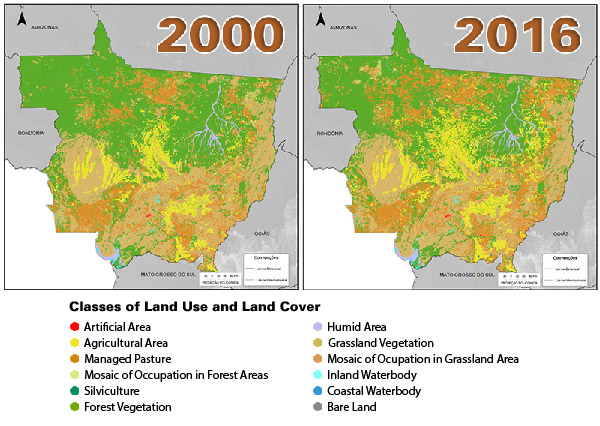
Evolution of Land Use and Cover in Mato Grosso – 2000 and 2016